Category Archives: Water

Red Canyon

Rather than driving all the way down to Eilat on highway 90 you might want to consider a detour, taking a right onto highway 13 and then a left onto 40 which follows the Israel Trail. After 38 km you’ll come to Shizaphon Junction where you’ll find an organic, vegetarian restaurant run by the folks of Kibbutz Naot Smadar, a lovely place to take a break.

At the Pundak you can also buy products from the kibbutz, artisan goat cheeses, bread, jams, fruit leather, dates and wine – everything you’d need for a picnic. I highly recommend that you try their goats yoghourt ice cream with the homemade apple cake. Mmmm, delicious.

From the junction if you continue on highway 40 you’ll come to the kibbutz itself, like a magical kingdom appearing out of the desert. Many of the kibbutznikim are artists and they’ve built a studio space and gallery that you can visit.

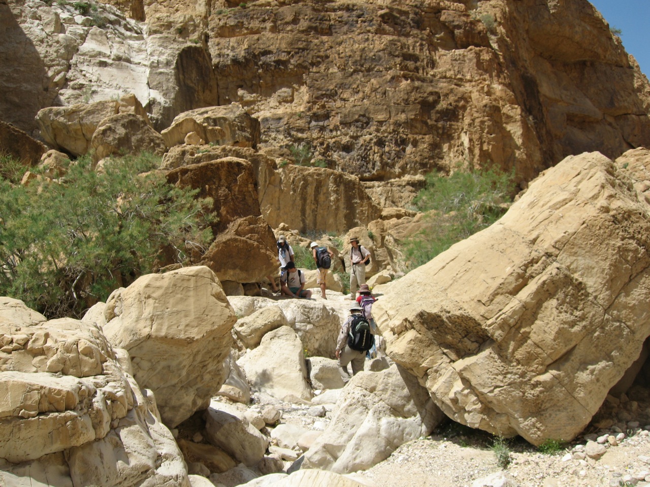
Afterwards retrace your steps and take highway 12. After about 3 km there will be a dirt road to your left that will take you to Shaharut where you can sleepover and go on camel trips. Afterwards retrace your steps and continue on highway 12 south for about 50 km until you see the cutoff for the Red Canyon – Wadi Shani on your left. Follow the dirt road to the parking area.

From there you follow the green trail markers and descend into the small canyon, no more than 3 meters in width with a height of up to 30 meters, created over years by water erosion of the sandstone.

Red Canyon

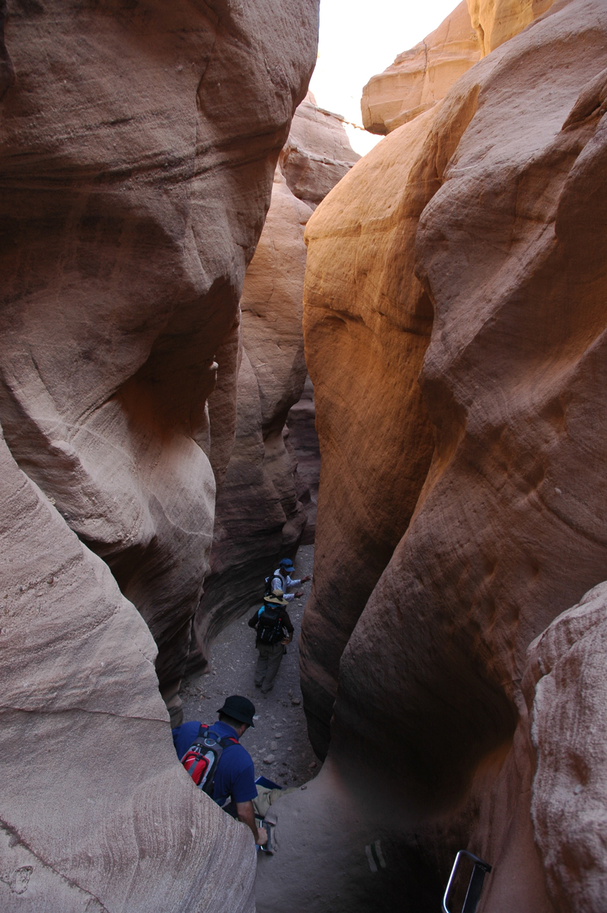
The dominant color of the rock is red with shades of pink and purple. It reminded me of a smaller version of the canyon at Petra. The hike is suitable for families. To return either retrace your steps through the canyon (if there aren’t a lot of people) or climb up out of the canyon where the streambed widens and take the path with a great view of the canyon below. The Red Canyon is one of the places that I recommend to people who are interested in a tour focussed on photography.

If you are continuing to Eilat there are 2 lookout spots that are worth stopping at: Har Hizqiyahu at 838 meters for a view east to the Edom Mountains in Jordan and west to Moon Valley in Egypt and Mount Yoash at 734 meters from which you can see 4 countries on a clear day: Jordan, Egypt, Saudi Arabia and Israel.

Olive Park, Ramat Rahel

Concepts of rootedness and disconnection which mark the complex relation of our civilization with the earth are central to the world of oppositions manifested in the sculpture’s plastic form. Olive trees, ancient symbol of strength, fertility and peace, continue their life in a transplanted and disconnected state.

Ran Morin, environmental sculptor

The park lies at an elevated and windy location overlooking Jerusalem and Bethlehem with views over the Judean desert, Herodium and as far as the Dead Sea. In preparing the park, mature olive trees were transplanted in 1987 from the experimental orchard of Prof. Shimon Lavee of the Vulcani Institute in Rehovot. Besides various types of olives that grow in Israel, there are olive trees that originate from Greece, Italy, Spain, France, Turkey, Algeria, Morocco, Argentina and the USA.

In the center of the park is a structure of 3 steel columns covered with basalt stone aggregate that form a triangle, sitting on a stepped platform of concrete and Jerusalem boulders. On the top of the columns, 11 meters in the air, three 80 year old olive trees are growing, supported by a customized drip irrigation system.

Part of the artistic project deals with the properties and spiritual harmonies of the number three: 3 monotheistic religions, 3 forefathers of the Jewish people, 3 Magi who came to visit Jesus, etc. The location at the edge of the desert and near a blood-stained political border connects the different elements in its surroundings and relates to more ancient periods when olive trees and plowed earth were characteristic of man’s intervention in this arid landscape.

Morin’s projects can be construed to have political undertones, mainly because it can’t be avoided in Jerusalem and the areas where he works. Personally, however, Morin tries to stay away from such sensitive issues. It’s hard though: “I am dealing with earth and olive trees and actual places where there are borders. A Palestinian once told me, ‘Okay we don’t have to fight over the land; we can grow the trees in the sky’.”

Yerushalayim shel maala, heavenly Jerusalem. If we could only bring it down to earth.

Aqueduct at Caesarea

The first aqueduct (one closest to water) was built by Herod at the time the city of Caesarea-Maritima was founded and brought water from the Shuni spring, south of Mount Carmel, about 10KM to the northeast of the city. The water flowed on a single raised channel supported on kurkar arches.

When this was not sufficient, a second “lower” aqueduct was built by the Legions of the Emperor Hadrian (2nd C CE). It brought water from Tanninim (Crocodiles) river. This section, with a tunnel of about 6KM long, was tapped into the older aqueduct, and doubled its capacity and its width. The builders used the same building materials and style, so it may be difficult to see that the pair of channels were built at different times. The aqueduct continued to supply water to Caesarea for 1200 years.

To find the start of the second aqueduct drive just past the entrance to Beit Hanania you will find the northern section of the aqueduct and the second aqueduct (Hadrian) connecting to the older one (Herod).

Aqueduct at Beit Hanania

In this section there are two stone tablets that were placed into the wall by its builders, the legion of the Emperor Hadrian. The right tablet clearly shows: “IMP CAES(ar) TRIAN HADR(ianus)”. The other tablet is of the Tenth Legion (the Imperial eagle without its head standing on a wreath).

IMG_5984

The Israel Trail winds its way beside the aquaduct, through the Arab town of Jizr a-Zarka and then south along the coast to Caesarea.

DSC_0195

On the beach closer to the Caesarea archaeological park there is another section of the aqueduct.

Aqueduct just north of Caesarea

In fact it makes a great hike with the whole family following the aqueduct at Caesarea north along the beach to Dor (where you can visit the Mizgaga museum) or continue a little further to Hof Habonim.

Related articles

Nymphaeum at Herodium?

I’m a tour guide who often does tours at Herodium, the palace complex built by King Herod about 15 km south of Jerusalem and where, according to Josephus, Herod was buried. Ehud Netzer, in excavating Lower Herodium, described a building that he called the Monumental building at the end of of an elongated course. He suggested that the building could have been Herod’s burial place. Since then Netzer has discovered the base of a mausoleum with finely carved decorations and 2 sarcophagi on the north-western side of the hill.

On p. 38 of his booklet entitled Herodium (published 1999) Netzer writes

“Present-day visitors are always puzzled by a series of grooves cut into all of the half-columns. These grooves were apparently carved to accommodate a piping system which was probably added later during the period of the Roman pro curators, who may have converted the hall into a nymphaeum.”

Interesting. The nymphaeum that comes to mind in Israel is the one in Bet Shean. So I looked up nymphaeum and came across a very interesting article about Hadrian’s Villa near Tivoli:

http://www.dartmouth.edu/~classics/rome2005/updates/week9_10/nov14.html

There’s a diagram of the Canopus/Serapeum complex, an open air triclinium/nymphaeum and water course. This is very reminiscent of the Monumental building and course that Netzer describes (course at Lower Herodium is ~300m in length and ~25m wide).

A plan of the Canopus/Serapeum complex (original image from Sear, p. 180.)

There is another nymphaeum in the plan, in the area called the Piazza d’Oro (based on Figure 103 on p. 177 of Sear’s Roman Architecture; the central dark grey area comes from Figure 114 on p. 96 of Macdonald and Pinto’s Hadrian’s Villa and its Legacy).

(A) A large colonaded pool with garden.  (B) The octagonal entrance vestibule.  (C) The eight-sided space on the southeastern side of the courtyard.  (D) The nymphaeum with five niches for fountains of flowing water.

The article includes a photo of the remains of this nymphaeum, made up of 6 niches (which would have held the fountains) separated by pilasters. There is a channel that would have allowed water to run from the nymphaeum to the pool in the courtyard.

I was struck by how similar this is to the Monumental building, so I have included a photo of it here.

In guiding, I’ve had a number of tourists ask me what the curved cuts in the stone in the lower part of the pilasters (between the niches along the walls, 2 in the end, 3 on each side) were used for. If this was designed as a nymphaeum (either in the time of Herod or by later Roman governors) perhaps the channels were used for water. The course and building are just south of the large pool.

Hiking Nahal Dragot

Driving along the shore of the Dead Sea on our way to Masada and Ein Gedi, I usually point out the cutoff to Nahal Dragot – there are some great hikes here if you are up to the challenge. In fact, Nahal Darga as it is also called, is a kind of test for Israelis.

Nahal Dragot

From the center at Metzukei Dragot, there is an unpaved road (if you were to continue north you could go as far as Herodium), take the turn to a lookout point with a great view of the canyon, the deepest part of Nahal Darga and a hint of what awaits.

IMG_1055

Returning to the main road and continuing westward we come to the start of the black trail. From there it is a short hike to the Murabat Caves, 3 caves, side by side on the northern cliff. It was here that letters signed Bar Kosiba were found, evidence that the mythical leader of the Bar Kochba Revolt against the Romans in 132-135CE did in fact exist.

Letter of Shimeon bar Kosiba to Yehonathan, son of Be’ayan:
Peace! My order is that whatever Elisha tells you, do to him and help him and those with him. Be well.

From here it’s about a 150 m. descent to the start of the canyon. It will take 4-6 hours (4 km) to hike this part of the narrow canyon with more than 50 meter high walls, dry waterfalls and pools of water in natural craters (note there are places you will have to swim across). At the end of the hike the wadi widens and crosses highway <90> about 1½ km from the Mezuke Dragot cutoff, estimate that to complete the hike will take a full day. There are metal D-shaped rings hammered into the rock in places to help you on the descents but it’s probably also worth having at least 20m. of rope. A guide is recommended.


Amitai in Nahal Darga, photos AdirChai Haberman-Browns, used with permission.

You should also read this article http://www.jpost.com/Travel/AroundIsrael/Article.aspx?id=135713

Katlav

Katlav

Katlav is the Hebrew name of a striking, red-barked evergreen shrub or small tree native to the Mediterranean region (grows as far north and west as France and Ireland), the Strawberry tree or Arbutus Andrachne. The bark is smooth and sheds during the summer, leaving a pistachio green color, which changes gradually to a beautiful orange brown. The small red berries, tasting a little like tart strawberries, ripen in November.

There is another related tree, Arbutus unedo, that also grows in this region. The leaves have a saw-tooth edge and the fruit is bumply, orange-red when ripe. The name ‘unedo’ is explained by the Roman historian, Pliny the Elder, as being derived from unum edo “I eat one”, which seems appropriate as most people find the fruit bland and mealy.

One advantage of hiring a local guide is that you get the opportunity to get inside, to be initiated into what the locals do, things that most tourists never experience. In and around Jerusalem there are some very special hikes and one in particular is Nahal Katlav in the Judean Hills, named for the abundance of strawberry trees growing there. There is also the possibility of hiking to a maayan, a natural spring that fills a pool cut into the rock, that is just the perfect solution to a hot summer day. Before we head out we will pick up some artisan bread, cheese, salads, etc. for a picnic, drive into the hills, hike to our destination and enjoy. These are outings for the whole family.

Nahal Katlav is a tributary of the Sorek river which is biblical Hebrew for a choice grapevine. Over the years, this region was known for its grapes, and today there are a number of fine boutique wineries in the Judean-Yoav region. For those interested in wine, these outings can be combined with a visit to a winery in the area. There is even a winery called Katlav.

It is very impressive to stand in the presence of an ancient tree. Near Kibbutz Tsuba are 2 very old trees, a 1200 year old olive tree and a 800 year old oak. Although I am not aware of such an old strawberry tree there is a magnificent specimen that is about 80 years old at the Jerusalem War Cemetery on Mount Scopus.

Katlav in cemetery