Tag Archives: desert hike

Negev

Ben Gurion grave, Sde BokerI’m thinking about the Negev. The Negev covers some 13,000 km² (4,700 sq mi) and makes up more than 55% of Israel’s land area. Ben Gurion, Israel’s first prime minister and statesman, saw the Negev as the key to a viable Israel. He joined Kibbutz Sde Boker in the Negev in 1970, lived the last 3 years of his life there and is buried overlooking Nahal Zin.

There are some remarkable sites in the area for hiking and photography : Ein Avdat, white cliffs, reflection pool and Griffon vultures (like angels) soaring overhead and a hike across a high plateau to a spring, Ein Akev, in a stream bed. This part of the Negev is a rocky desert, a melange of brown, rocky, dusty mountains interrupted by dry stream beds, in Hebrew nahal, in Arabic wadi. The photographs below are the view across the plateau from an early morning hike with Bonna in August 2013. This week, Rosh Hodesh Tammuz, we celebrate our 34th wedding anniversary.

In the first photo, there is a lot of foreground, brush, rocks, sand stretching to the distant horizon. In the second, there is little foreground and a lot of sky. The shift in the horizon line creates a dramatically different effect. I hope they capture some of the barrenness, expanse and spiritual power of the Negev. 

Rocky Negev

Negev sky

Through My Lens, Textures

For a change, rather than taking photographs of objects, try textures. Here are some close-up photographs that I took focussing on the textures that you can find occurring in nature. Try to guess what the object is in the photograph and where it might have been taken – I’d be interested in your comments. All photos were taken in Israel with a Nikon DSLR with a 18-200mm lens.

Wavy texturePeratzim wavesThis is Nahal Peratzim, at the southern end of the Dead Sea, a great place for a moonlit hike.

Brush texturePeratzim bushAlso Nahal Peratzim, a dry bush at the entrance to the canyon forms the texture and color of an interesting photo.

Dead Sea textureDead SeaThe salt and pebbles form these textures in the Dead Sea at Ein Boqeq. The dark line of land delineates the sea and the sky.

I also have some colorful photos from the Makhtesh HaKatan, Israel’s smallest erosion crater. For more photographs check out the PHOTOGRAPHY tab on the menu.

Photo of the Week – Nahal Darga

A limestone canyon formed by water erosion over many years beckons – Nahal Darga runs to the Dead Sea. Water fills depressions in the stone floor of the canyon so there are places on this hike where you have to swim across pools of water. Make sure to put your camera (I brought along a smaller one on this hike), car key and cell phone in a watertight container so they won’t get wet.

Please share this post with your friends by clicking on one of the icons below

Nahal Darga

The technical details – the photo was taken with a Lumix (point and shoot) digital camera on March 26 (ISO 80, 4.1mm, F3.5 at 1/100 sec).

Photographs on this website are © Shmuel Browns (unless marked otherwise) – if you are interested in purchasing one of my photos or using one of my photos for your own project please contact me.

Hiking the Makhtesh

Approximately 50km from the development town of Dimona named after the Biblical city of the same name mentioned in Joshua 15:21-22 are two examples of makhteshim or erosion cirques, unique to the Negev and Sinai deserts. So far geologists have only identified 7 makhteshim, Makhtesh Ramon, Makhtesh HaGadol, Makhtesh HaKatan and two even smaller ones on Har Harif in the Negev; there are two in the Sinai. One of the special things about the Makhtesh HaKatan is that because of its small size you can view it in its entirety, a 5km by 7km oval shaped bowl with steep walls of resistant rock, in this case limestone and dolomite that covered a softer layer of chalk and Nubian sandstone that comes in colors of pink, purple, yellow and green.

There are two access points into the makhtesh, Maale Hatzera on the northern wall is more gentle, an ancient camel pass and Maale Eli. We started our hike from Maale Eli a route originally discovered by local Bedouin that traverses the steep limestone (from the Cenomanian epoch 100 million years ago) walls of the makhtesh connecting the floor of the makhtesh with Hatzera Ridge. I’ve heard various reasons for the name – Eli means upper from the same root as ascend; Eli means pestle to the bowl-shaped mortar of the makhtesh. In fact, it is named after Eli Ben Zvi, son of Rahel Yanait and Yitzhak Ben Zvi who was the second president of Israel. Eli was wounded during a training exercise with the Palmach in the makhtesh in the 1940s and this ascent was discovered in evacuating him to the nearest road joining Beersheva to Maale Aqrabim, the Scorpion Ascent built by the British. Like Masada the Makhtesh HaKatan became a symbol of knowing the desert and the land of Israel by a people who had come home after 2000 years of exile.

We descended the steep walls of the makhtesh on a serpentine trail with the aid of rungs and railings, 400 meters to the floor of the makhtesh. From there we followed the red trail east (also marked as part of the Israel trail) passing hills and cliffs of colored sandstone to the mouth/exit of the makhtesh. The colors are produced by iron oxides, the sand from erosion of the Arabo-Nubian Massif carried all the way here by riverbeds. The hike is suitable for good hikers and should take about 4 hours.

By the paved road that leads to the exit is an electricity tower and piled at various levels are branches that look like the nest of some large bird – they were deposited there in 1994 and 2004 when there were torrential rains and the water reached that high.

For those looking for a long day hike you can follow the Israel trail starting at the Tamar fortress and descending into the makhtesh at Maale Hatzera. You walk south on the blue trail to the mouth of the makhtesh and when you get to the water pumping station you take the red trail west across the makhtesh climbing up at Maale Eli. Continuing another 10km to the Makhtesh HaGadol will take you past the spring of Ein Yorqeam, definitely worth a visit.

The British figured that it would be worth drilling for oil in the makhtesh, erosion has already gotten rid of the hard rock and hundreds of meters of sand. They did not find any but for the same reason it is worth drilling for water. The sand in the makhtesh acts as a large aquifer though the water is quite salty. The water is piped to a reservoir on Mount Tzafit from where it is used by industries on the Rotem Plain.

Hiking Israel

Hiking throughout Israel is a national pastime – youth groups, the scouts, the army connect to the Biblical land with their feet. School classes have a tiyul shnati, an annual hike. Many young people who have just finished their army service reconnect with friends by hiking together on Shvil Yisrael, the Israel Trail, a 945 km trail that crisscrosses Israel, from Dan in the north to Eilat in the south. There is also a Golan trail, a Jerusalem trail, the Jesus/Gospel trail, a hike Sea to Sea from the Mediterranean to the Sea of Galilee. If you want to really experience and understand Israel you should take to the trails. Hiking takes you off the beaten track and besides the beauty of nature you will often come across archaeological ruins from thousands of years ago. If you don’t have a lot of experience hiking in Israel it’s recommended you hire a guide. Besides guiding you on the trail I can suggest what to bring, help with logistics, transportation and explain the nature and history and archaeology on the hike.

Israel is a small country which means you don’t have to travel far to start your hike. But although small in size there is incredible diversity so there are many different hiking experiences. Living in Jerusalem I know some hikes that are very close by, for example shvil hamayanot a trail that takes you to natural springs and pools that are particular to the hills of Jerusalem. A hike in Nahal Katlav (a nahal or wadi is a dry stream or river bed) in December is an opportunity to see wildflowers like crocus blooming after the first winter rains.

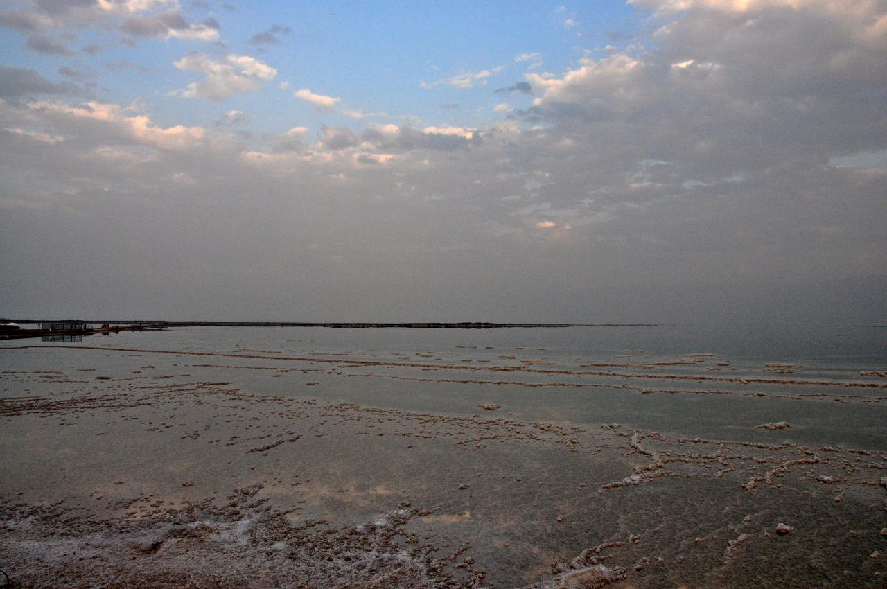
Jerusalem is a great base for day hikes because of its location in the hills and on the edge of the Judean desert and only a half hour drive to the northern edge of the Dead Sea. For starters I’d recommend hiking Nahal Og, desert landscape, narrow canyon, iron rung ladders – a really classic Israeli hike. Nearby is Wadi Qelt with a hike that takes you to a monastery hanging on the cliff. There are two wadis at the Ein Gedi reserve, Nahal David is the one most people hike and Nahal Arugot; you can choose trails, from 20 minute family hikes to challenging 4-6 hour hikes that will take you to pools and waterfalls in the middle of the desert.

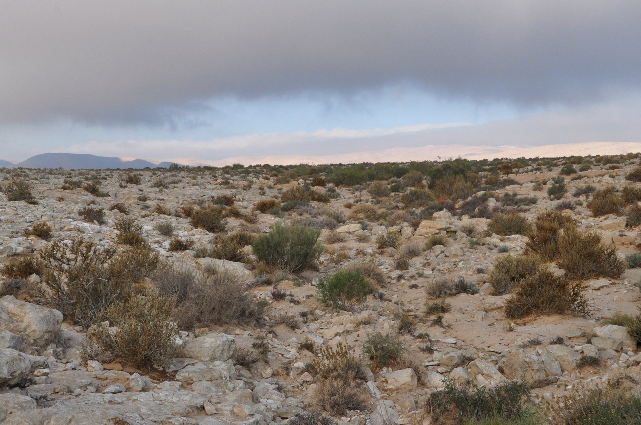
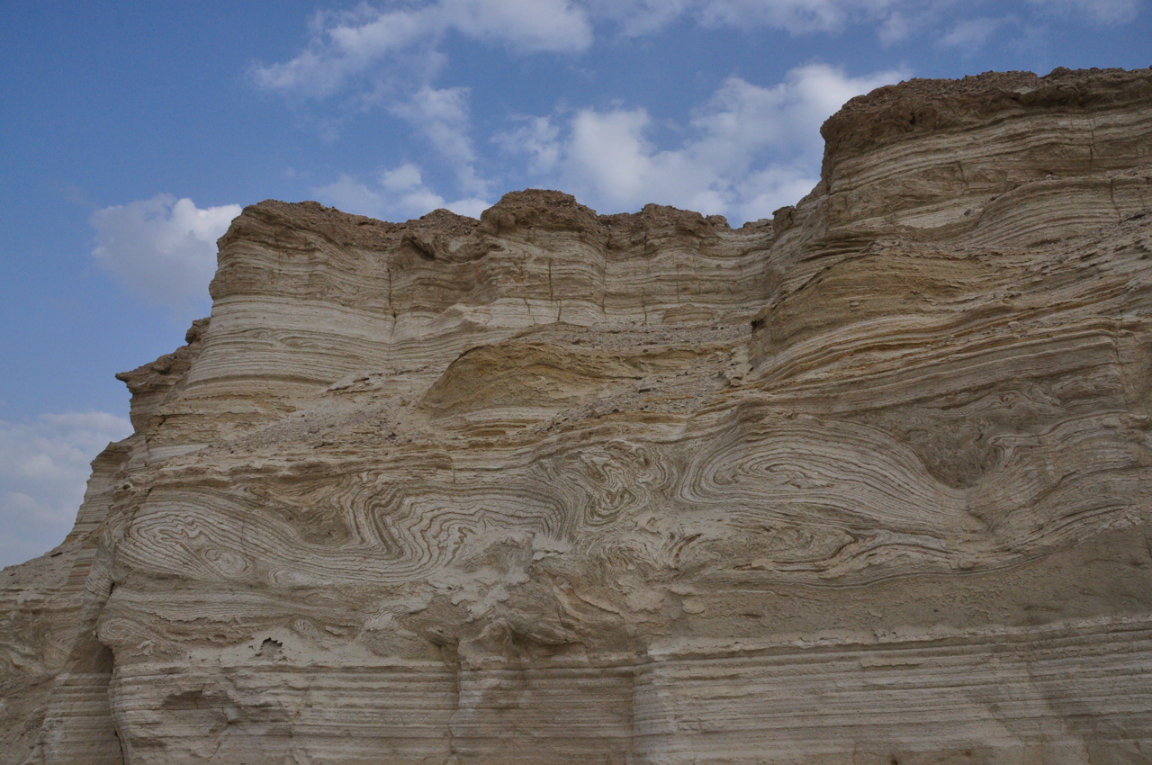
If you are planning to be farther south there is hiking at Mount Sodom, a salt mountain or try a night hike by the light of the full moon in Nahal Peratzim. The Negev south of Beersheva is another desert with its canyons, mountains and springs to explore. Unique to the Negev is a geological phenomenon called the makhtesh or erosion crater that should not be missed. Probably the most picturesque hike in Israel is a short hike that is appropriate for the whole family not far from Eilat called the Red Canyon where erosion has sculpted the red and orange sandstone cliffs.


In the north of Israel there is a hike in the Mount Arbel reserve, where you descend the steep cliffs and then climb back up with great views of the Sea of Galilee and the Golan. Just a little farther north is the Nahal Yehudia reserve with a whole variety of hikes, Meshushim (hexagonal basalt) pool, Nahal Zavitan, Gamla.

For good hikers there are two hikes that are legendary, in the north it is Nahal Yehudia and in the south Nahal Dragot. If you want to test your mettle against the real Israeli experience, these are the hikes. For recommendation on some dozen other hikes, click on this link https://israeltours.wordpress.com/category/hiking/
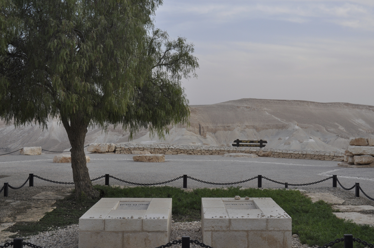
Nubian Ibex

Wild goats are very agile and hardy, able to climb on bare rock and survive on sparse vegetation. The Nubian ibex (Capra ibex nubiana) is a rocky desert dwelling goat found in mountainous areas of Israel and throughout the Middle East that eats mainly grasses and leaves. Archaeologists have found evidence of the ibex on cylinder seals and painted on pottery. You can find rock drawings of ibex on a hill above Carmei Avdat, a family farm where grape vines grow on original Nabatean terraces.

Ibex rock drawings

Across from the farm is the En Avdat nature reserve. I was hiking with a client in the canyon mid-morning and the sun was perfectly backlighting a grove of Euphrates poplar trees for a great photo. Near the entrance is a large Pistachio Atlantic tree with gnarled branches and strong roots anchoring it in a field of rocks. This tree was ablaze in reds and yellows – one of the things I miss is the beautiful autumn colors I used to see in Canada. As I looked up among the branches I saw an ibex that had climbed 10 feet up into the tree. Unfortunately, I didn’t have my camera.

There is a good chance to see ibex at nearby Sde Boker, overlooking Nahal Zin. Farther south, you can see ibex in the parks and on the edge of the makhtesh at Mitzpe Ramon.

Ein Gedi is a great place for a hike, to take a family to experience springs, waterfalls and pools in the desert. Today as we pulled into the parking lot, we saw a male ibex on the roof of a Eldan rental car so that it could reach the leaves of a nearby tree. I know ibex are good climbers and the ibex in the Ein Gedi reserve are used to people but that was certainly a surprise.

Ibex at Ein Gedi on car roof