Category Archives: Hiking

Spring wildflowers


From mid-February the country is covered with a mantle of wildflowers. Though it may vary from year to year, this is when

“the winter is past, the rain is over and gone, the wildflowers appear on the earth…” Song of Songs.

Tradition marks the beginning of spring in Israel with the flowering of the almond tree (shkedia in Hebrew) at Tu B’Shvat. One of the first flowers to bloom is the red anemone (anemone coronaria from Greek Άνεμος ‘wind’, in Hebrew kalaniot), a perennial in the buttercup (Ranunculaceae) family. Don’t confuse the anemone with red poppies (of the genera Papaver) that bloom later in the season

  • anemone has a variable number of petals but never less than 5; poppy has 4 petals
  • anemone floral bud is cupped by 3 dissected leaflets that remains; poppy has 2 that drop away

On a tour of the Golan last week we saw red anemones growing on the hill as we walked down into the wadi to Breikhat Meshushim (Hexagonal Pool).

From there we continued north on the Golan to Saar Falls where I found this field of lupines with a view of Nimrod fortress in the background. The legume seeds of the lupine were popular with the Romans who spread the plant’s cultivation throughout the Roman Empire. Today there are 2 lupins that are indigenous to Israel, the blue Lupinus pilosus and white-grey Lupinus palaestinus. Lupins can fix nitrogen from the atmosphere into ammonia via a rhizobium-root nodule symbiosis, fertilizing the soil for other plants. This adaption allows lupins to grow in poor quality soil and in fact, improve soil quality so that other plants can grow.


On the same trip I came across red tulips (Tulipa montana) a member of the lily family growing on the hill overlooking the Sea of Galilee above Ein Gev.

Mount Sodom

Mount Sodom

South of Masada along highway 90 there is a hike up Mount Sodom, a hill that is made up almost entirely of halite or rock salt. It is 226 meters above the Dead Sea with some great views (and photography opportunities) but still 170 meters below sea level. Don’t miss the rock formation that has separated from the cliff face due to weathering. It is known as Lot’s wife, a reference to the Biblical story of the destruction of Sodom and Gomorrah and how Lot’s wife looked back as they left and was turned into a pillar of salt. Interestingly there are other rock outcrops that are called Lot’s wife in other parts of the world, check Wikipedia for some fascinating accounts like a basalt pillar, a deserted, volcanic island in the Philipines Sea, at the southernmost tip of the Izu archipelago in Japan.

Lot's wife as a pillar of salt, © 2009 Shmuel Browns

Dead Sea pools

Masada at Sunrise

Masada is one of the most visited historical/archaeological sites in Israel, an isolated rock cliff in the Judean desert overlooking the Dead Sea.

Masada cable carAlthough there is a cable car that will take you to the top of the mountain, a tradition has grown up to climb the Snake Path, a zig-zag trail, early in the morning in order to reach the summit in time to watch the sunrise – that’s what we did. The top is only 59 meters above sea level but remember that you’re starting at about 400 meters below sea level. You should be able to climb it in 45 minutes to 1 hour. If you want to do this the best place to stay the night before is the youth hostel at the base of Masada.

I recently read an article on the Israelity website about a group of 7 seniors from the Cedar Village retirement community near Cincinnati who came to Israel to celebrate their bar/bat mitzvahs and tour Israel including climbing Masada – their average age was 85 years old, the oldest was 97!

I guided two families traveling together, a group of four adults and five children, during their time in Israel. When we reached Masada and saw the mountain some were interested in climbing the Snake path. We didn’t really have enough time so one of the Dads suggested running it. At first no one took him seriously, so Chris said he’d do it. I showed him where the path started and he was off. The rest of us took the cable car and on our way up looked for Chris. I finally saw him on the last turn of the path before the summit – his time 17 minutes! For Bernie’s description of their experience check out their blog at http://keepingupwiththemounts.blogspot.co.il/2011/11/masada.html

Masada (from Arad)

Another option is a nice hike that starts at the same but splits from the Snake Path, you walk north on the red trail following the circumvallation wall built by the Romans around the mountain. You pass the 4th siege camp (northernmost) and follow the trail west and then south. As you climb there’s a great view of the Northern Palace hanging on the cliff and the water cisterns on the western side. You can go to see the cisterns and/or climb the Roman ramp to the summit.

Hiking Nahal Yehudia

Day 2: Hiking Nahal Yehudia
After a breakfast of fruit and homemade granola we drove to Nahal Yehudia off highway <87>. The hike is listed as appropriate for good hikers who can swim as there are a couple of places where you have to climb down the rock face with the help of handholds or a ladder into a deep pool that you have to swim across. The trail is one of eleven listed in the Park’s brochure on the Yehudia Forest Reserve, including Nahal Zavitan, the Meshushim (hexagonal basalt pillars) pool and Gamla which includes the archaeological remains of the Jewish town that fought against Vespasian at the start of the Jewish Revolt in 66CE and Griffon vultures that can be seen flying overhead. There is parking, bathrooms, drinking water, a snack bar and information center (the park warden we spoke to was very helpful); the entrance fee was 20 NIS per person. Note that you must start out on the trail by noon.

DSC_0161

The hike starts above the wadi, walking through a deserted Syrian village built on the remains of an earlier Jewish one of basalt field stones from the Roman-Byzantine period. Remains of a wall have led archaeologists to suggest that Yehudia is Soganey, one of the three fortresses (the other two are Gamla and Sele’ukya) in the Golan built by Josephus at the time of the Roman Revolt. You walk on a path strewn with basalt, by pasture land where you may see cattle grazing.

DSC_0171

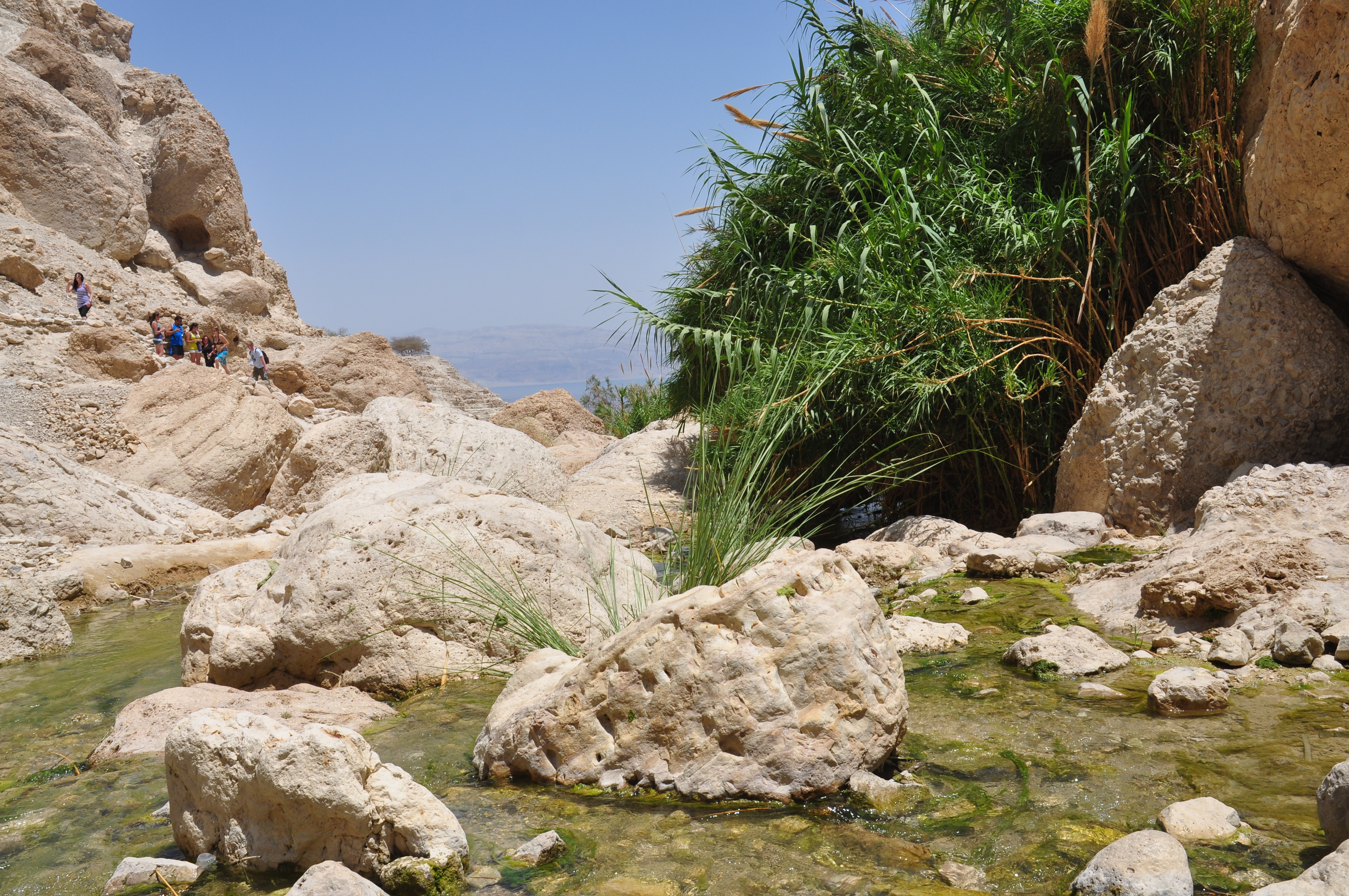
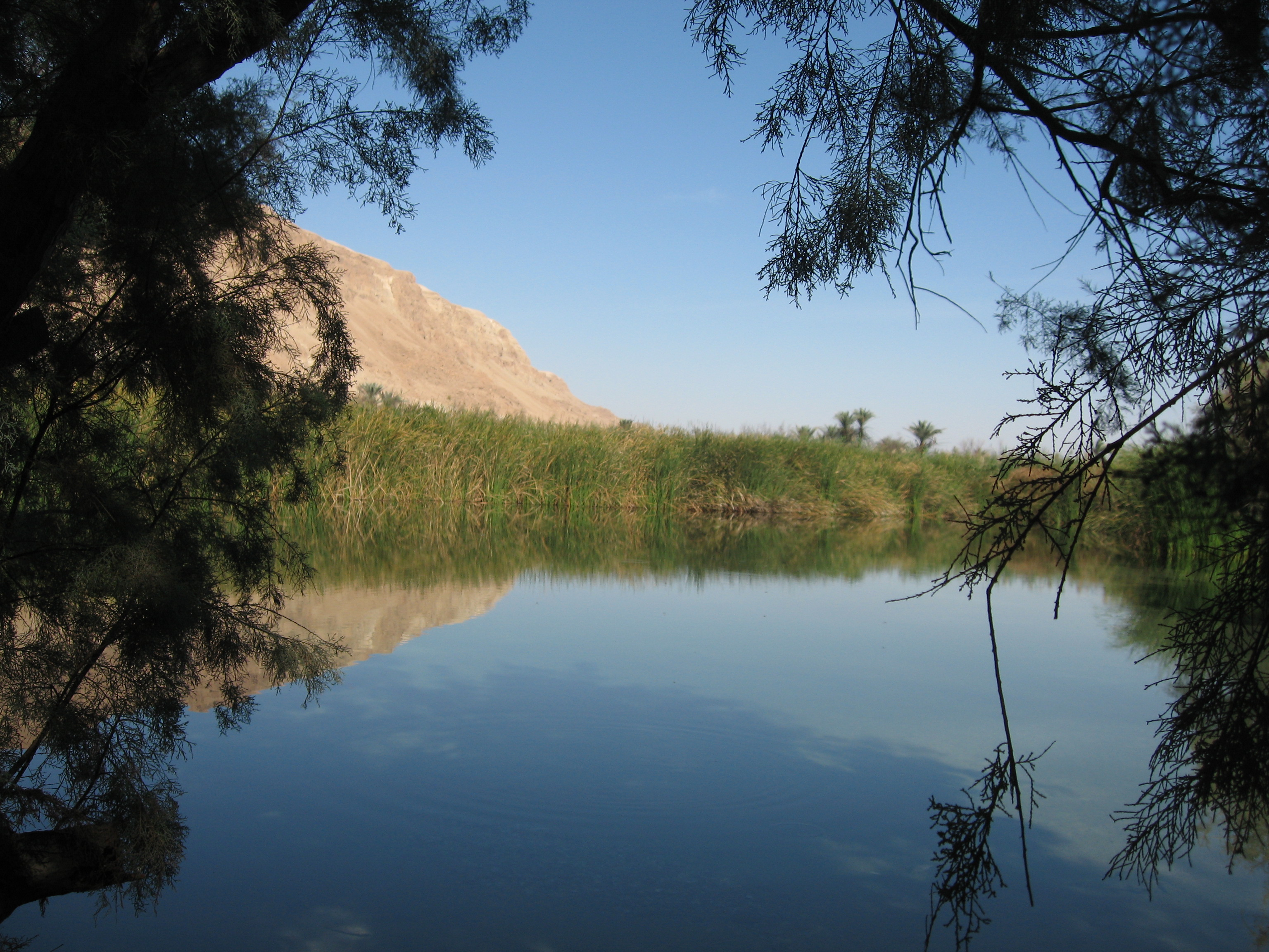
Then you walk down into the wadi to the Yehudia Falls and the first pool, good for a cool dip especially if it’s a hot day.

DSC_0177

At this point we changed out of our hiking boots and into water sandals as there are places where you walk in the water. Continuing along the wadi you get to the first descent. U-shaped handholds have been attached to the rock to help you get down about 4 meters. This is just your warm up. The trail brings you to a cliff where you descend 9 meters by metal ladder into a pool. There is no place to stand, you step off the bottom rung of the ladder and swim across to the other side of the pool.

DSC_0184

The challenge is what to do to keep your gear dry (and in this day and age with cell phones, cameras, car keys with electronic locks, etc. we have stuff that won’t work if it gets wet). We used the double garbage bag technique but also saw a group float their packs across on a small inflatable boat, you can rig up a rope and omega your pack across or probably safest, pack in professional waterproof bags used for kayaking.

After traversing the pool you come to another descent, this time about 4 meters with only handholds. At the bottom you have the option of swimming or walking across the pool as it isn’t that deep. Be careful as it is slippery walking on the rocks. The water can be quite cold so it’s great that there is a place in the sun to sit on some large rocks and have a snack.

DSC_0182

Using the 2 large plastic bags that we had brought for our packs, we picked up a bunch of garbage that we carried out with us. We continued along the wadi, sometimes walking on the rocks, sometimes in the water. At the well marked junction you can leave the red trail to take the green back to the Syrian village or continue  along the wadi a bit further to one last pool and waterfall. Then we backtracked and took the green trail up out of the wadi, back to the Syrian village and the trail head. It was just the middle of November but there were already cyclamen and narcissus in bloom.

You can view a fuller set of photographs from this Golan trip on Flickr at http://www.flickr.com/photos/27944012@N06/sets/72157622790431204/

Negev desert

The Negev desert, shaped like a 4700 square mile inverted triangle in the south of Israel, makes up more than half of the country’s land area. I can arrange to make a visit to the Negev part of your itinerary, you have to experience the desert to understand its importance.

Geographically the Negev can be divided into 5 areas: the northern, western and central Negev, the high plateau and the Arava Valley. This article focuses on the high plateau area, Ramat HaNegev (Negev Heights). The plateau stands between 370 metres and 520 metres above sea level and has extreme temperatures in summer and winter and significant differences in temperature between day and night. Even though the area gets only 100 mm of rainfall per year and the soil is poor and quite salty, Israel is successfully growing olives, pomegranates, pistachios and grapes for wine.

DSC_0042

Here are some places to add to your itinerary as you explore Ramat HaNegev.

  • Kibbutz Revivim is growing 5 varieties of olives using brackish water and selling the olives and olive oil in an upmarket boutique dedicated to their products in Tel Aviv.

DSC_0017

  • Park Golda includes a lake and picnic tables to eat your lunch or for an unforgettable desert experience, try Beduin hospitality in a black goat’s hair tent followed by a camel ride.

IMG_0931

  • The Large Makhtesh is one of 3 craters in the region, a unique formation to the Negev, where the inside of a mountain is eroded by water, leaving the outer shell.
  • Visit the tzrif on Kibbutz Sde Boker to get a glimpse of how Ben-Gurion and Paula lived. The Ben-Gurion Institute, a research facility for the study and the dissemination of his writings, offers visitors a multi-media program about the man and his vision.
  • You can visit a string of family farms along route <40> for wine and cheese tasting and even sleep over in one of their cabins under the desert stars. On farms that are growing grapes and making wine, the vines have been planted on the same 1500 year old terraces that were prepared by the Nabateans and take advantage of runoff from the winter rains. These farms are also a symbol of Israel’s pioneering spirit in the 21st century, composting their waste, recycling their grey water and generating electricity using solar photovoltaic panels.

DSC_0033

  • Hike into the canyon at the Ein Avdat National Park with springs, pools and waterfalls, an oasis in the desert or from the Roman bath house (below Avdat) supplied with water drawn from a well tunneled 70 meters through bedrock hike north along the Israel Trail to the Ein Eikev spring that flows year round.
  • Visit the remains of the Nabatean city of Avdat which was probably the regional capital. Located at the crossroads that join Petra in Trans-Jordan to Eilat and to Gaza, Avdat controlled the passage of the caravans from India and Arabia. Conquered in 106 CE by the Roman Emperor Trajan, it lost its importance when a road was built between Eilat and Damascus. Avdat adjusted by adopting agriculture, particularly the production of wine, as its means of subsistence. Numerous terraced farms and water channels were built throughout the region in order to collect enough run-off from winter rains to support agriculture in the hyper arid zone of the Negev. At least five wine presses dated to the Byzantine period have been found at the site showing us how important wine-making was in this region. In the Byzantine period (5th and 6th century) a citadel and a monastery with two churches were built on the acropolis of Avdat on the ruins of earlier pagan temples. The town was totally destroyed by a local earthquake in the early seventh century and was never reinhabited.

Ein Gedi

Ein Gedi-waterfalls and pools

Ein Gedi (literally Spring of the Goats, refers to Nubian Ibex that come to the spring to drink) is an oasis in the Judean desert along the western shore of the Dead Sea. Here are two hikes (each about 5 km) in the Ein Gedi reserve that are perfect for families, Nahal David and Nahal Arugot.
On entering the reserve follow the marked the path and after about 15 minutes of easy walking we’ll reach the first waterfall, Mapal Shulamit that cascades 30 meters down the rock to a pool below. After a refreshing dip we’ll continue to a fork in the trail, we’ll take the steeper one on the right (the other path would take us back to the entrance) to the Shulamit spring and from there above the wadi to the Dudim cave. Retracing our steps we’ll continue to the Ein Gedi spring and beside it the flour mill. From there we can walk to the ruins of the Chalcolithic temple (3500 BCE), one of the oldest remains of human settlement in the Judean desert. We’ll descend through a cranny along a dry canyon to discover a 50 meter high waterfall and a great view of Nahal David and the Dead Sea beyond.

Ein Gedi-Nahal DavidAccording to the Roman historian Pliny the Elder the area of Ein Gedi was settled during the Second Temple period by a Jewish ascetic sect called the Essenes. The archaeological evidence uncovered by Hirschfeld suggests that they lived   near the spring where he found more than 20 tiny stone cells and two pools, one for irrigation and one a miqve or ritual bath. Pottery shards date it to the first century BCE.

The second hike starts from Tel Goren along the Nahal Arugot river bed past acacia trees and salvadora to a large pool used for irrigation of crops like balsam; the pool was filled by a channel that brought runoff from the wadi. Continuing we will pass reeds, maidenhead ferns, willow and poplar; we may see a rare orchid called Ben Horesh. A little farther the wadi narrows to a steep walled canyon at whose end is a waterfall and pool.
Excavations at Tel Goren by Mazar of the Hebrew University in  the 1960s show that the site was settled in the Israelite period and functioned as a royal estate for growing dates of the now extinct Judean palm Phoenix dactylifera, considered uniquely medicinal. Balsam was grown for the production of perfume (in Hebrew, afarsimon).
The Romans were interested in the production of balsam perfume; Mark Anthony confiscated the groves from Herod and gave them to Cleopatra. After their deaths, Herod was able to lease them back. During the Great Revolt, the Jews uprooted the groves so they would not fall into the hands of the Romans.
Excavations have revealed a small Jewish village and a synagogue from the 4th century with a beautiful mosaic floor. Written in Hebrew and Aramaic,  inscriptions list the signs of the zodaic and months of the year (later displayed graphically in mosaic floors in synagogues in Bet Alpha and Tiberius) and the expression “Peace unto Israel” (also found in the ancient synagogue in Jericho) and a dire warning at the end: “whoever reveals the secret of the town to the Gentiles – He whose eyes range through the whole earth and who sees hiddens things, He will set his face on that man and on his seed and will uproot him from under the heavens.” The secret seems to be the production of perfume from balsam.

En Feshka pondThe other natural source of fresh water in the Judean desert is Ein Feshka 30 km to the north of Ein Gedi. The lowest nature reserve in the world consists of 3 parts of which one is closed to visitors except research scientists who are studying the desert. The public part includes a small archaeological site from the Second Temple period and pools of fresh water, picnic tables and facilities for the enjoyment of visitors. The closed reserve is 1500 dunams (370 acres) that can only be visited with an authorized guide like me. It’s incredible to find a large freshwater pond with fish, shaded by trees in the middle of the desert next to the Dead Sea.