Tag Archives: Photography

Photo of the Week near Avdat

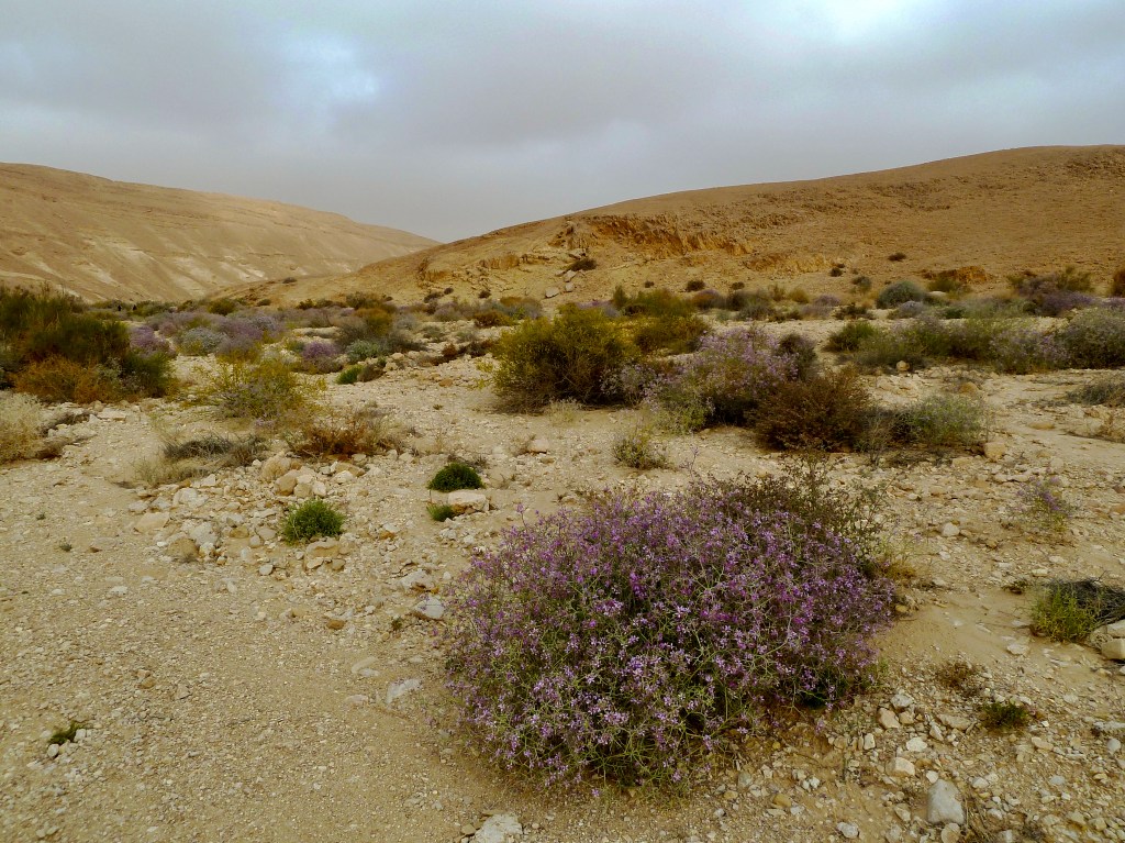
Route <40> connects the city of Beersheva in the middle of the Negev to the makhtesh, a unique geological formation at Mitzpe Ramon. Avdat, founded by the Nabateans in the 3rd century BCE, was the most important city on the Incense Route after Petra, “the rose-red city half as old as time” for some eight centuries until its destruction by earthquake in the early 7th century CE. This photo was taken across from Avdat in the area of Ramilye cisterns.

near AvdatYou can click on the image for a larger view (which may take some time to load depending on your Internet connection). Please share this post with your friends by clicking on the icons at the end of this message.

The technical details – the photo was taken with a Nikon D90 DSLR and 18-70mm lens in November (ISO 200, 18mm, F10 at 1/320 sec).

For more information about the Negev see my post at https://israeltours.wordpress.com/2009/10/26/negev-desert/

Photographs on this website are © Shmuel Browns (unless marked otherwise) – if you are interested in purchasing one of my photos or using one of my photos for your own project please contact me.

Just north of Timna continuing along the Israel trail you follow the Milhan ridge, a great area for hiking and photographs. We stayed overnight at the nearby campground, Be’er Milhan, a site that affords some protection from the wind (no toilets or running water). This photo was taken in the morning. Purple flowering bush is Spiny zilla (Zilla spinosa), a member of the brassicaceae family, you can eat the purple flowers which taste like cabbage.

Milhan well

The technical details – the photo was taken with a Lumix point and shoot camera in March (ISO 80,4.1mm, F4 at 1/320 sec).

For more information about desert wildflowers see my post at https://israeltours.wordpress.com/2011/03/14/desert-wildflowers/

Photographs on this website are © Shmuel Browns (unless marked otherwise) – if you are interested in purchasing one of my photos or using one of my photos for your own project please contact me.

Photo of the Week – Flamingo

The Greater Flamingo (Phoenicopterus roseus) is the most widespread species of the flamingo family. At the salt marsh you can find a colony of more than 100 flamingos that vacation just north of Eilat most of the year. According to expert Keith Marsh from Bird Forum besides the flamingos you will be able to spot white storks, herons, waders and a wide variety and number of raptors, especially in the autumn and spring during migration. There are few better birding areas in the Western Palaearctic than Eilat on the Red Sea coast of Israel where more than 420 species of birds have been recorded.

DSC_0458You can click on the image for a larger view (which may take some time to load depending on your Internet connection). Please share this post with your friends by clicking on the icons at the end of this message.

The technical details – the photo was taken with a Nikon D90 digital camera and a 50-500mm Sigma lens in November (ISO 800, 500mm, F6.3 at 1/400 sec).

FlamingosEven to get a group portrait (shot at 270mm) my regular 18-200mm lens would not have been enough.

Photographs on this website are © Shmuel Browns (unless marked otherwise) – if you are interested in purchasing one of my photos or using one of my photos for your own project please contact me.

Timna is a horseshoe-shaped valley in the south of Israel in the southwestern Arava about 30 km north of the Eilat just off of highway <90>. The area is rich in copper ore and has been mined by humans as far back as the 6th millennium BCE. An Egyptian temple from the end of the 14th century BCE dedicated to Hathor, the Egyptian goddess of mining was discovered. Water and wind erosion have created several unique rock formations and there are remains of fossilized trees that grew here some 150 million years ago. In 2002 it was declared a nature reserve. There are marked trails and paved roads to the various attractions; the Israel Trail traverses the valley.

Timna cliffs

You can click on the image for a larger view (which may take some time to load depending on your Internet connection). Please share this post with your friends by clicking on the icons at the end of this message.

The technical details – the photo was taken with a Nikon D90 DSLR camera with Nikkor 18-70mm lens in February (ISO 400,18mm, F10 at 1/200 sec).

Photographs on this website are © Shmuel Browns (unless marked otherwise) – if you are interested in purchasing one of my photos or using one of my photos for your own project please contact me.

Photo of the Week – Jordan River

The Jordan River extends just 251 km from the base of Mount Hermon through the Hula valley to the Sea of Galillee (Kinneret) and then down to the Dead Sea about 422 metres below sea level, which has no outlet (for comparison, the Nile, Amazon, Yangtze and Mississippi rivers are each more than 6000 km long). The children of Israel led by Joshua cross the Jordan river near Jericho from the east to conquer and settle the land (Joshua 3:15-17). The New Testament states that John the Baptist baptised unto repentance in the Jordan and Jesus came to be baptised by him there (Matthew 3:13). Pilgrims can immerse in the Jordan river at the traditional site, Kasr el Yahud, just north of the Dead Sea.

Jordan’s river is chilly and cold, Hallelujah.
Chills the body, but not the soul, Hallelujah.

You can click on the image for a larger view (which may take some time to load depending on your Internet connection). Please share this post with your friends by clicking on the icons at the end of this message.

The photo was taken just east of Kfar Blum. The technical details – the photo was taken with a Canon point and shoot digital camera in April (ISO 50, 7.7mm, F2.8 at 1/400 sec).

I’m including a more traditional view of the Jordan River shot at the same time and place.

Photographs on this website are © Shmuel Browns (unless marked otherwise) – if you are interested in purchasing one of my photos or using one of my photos for your own project please contact me.

Probably very few people have visited this site although it is in the middle of the country, on the edge of the Yatir Forest in the northern Negev, the largest planted forest in Israel. You can click on the image for a larger view (which may take some time to load depending on your Internet connection). Please share this post with your friends by clicking on the icons at the end of this message.

The photo was taken at Khirbet Anim – olive trees with the ruins of a 4thC synagogue in the background. The technical details – the photo was taken with a Nikon D90 DSLR camera on January 7 (ISO 200, 18mm, F10 at 1/400 sec).

For a closer view of the ruins of the synagogue see my post at https://israeltours.wordpress.com/2009/03/22/yatir-forest/

Photographs on this website are © Shmuel Browns (unless marked otherwise) – if you are interested in purchasing one of my photos or using one of my photos for your own project please contact me.