Tag Archives: Dead Sea

Photo of the Week – Dead Sea Works Moonrise

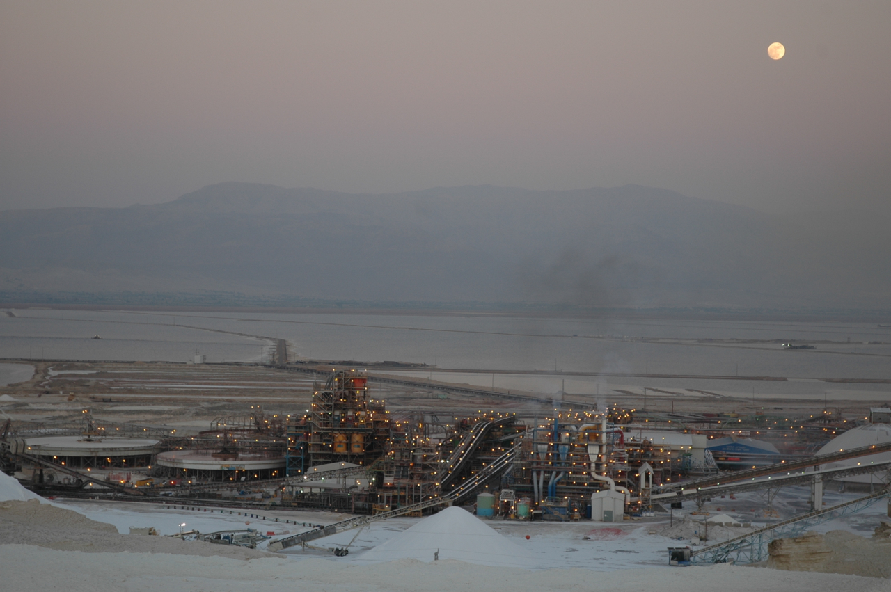
Highway <90> is a scenic road that runs along the western shore of the Dead Sea to Eilat. If you are driving at night the Dead Sea Works (DSW) appears like a mirage in the desert, like some alien space station of lights and structures.

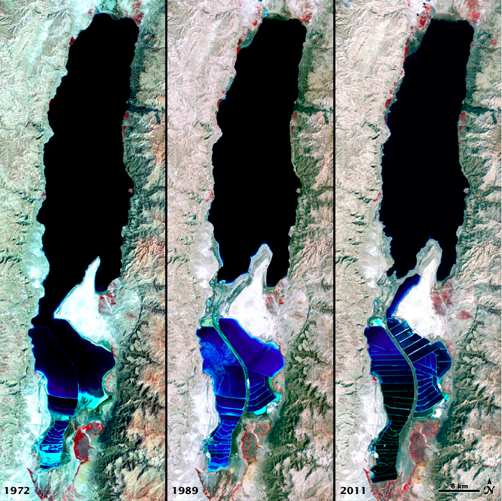
Because the Dead Sea is incredibly rich in minerals, sodium, potassium, calcium, bromine, and magnesium salts (21 minerals, twelve of which are not found in any other water body) it is a desirable and profitable location for mineral extraction. The DSW is the world’s fourth largest producer and supplier of potash products.

Dead Sea Works MoonriseYou can click on the image for a larger view (which may take some time to load depending on your Internet connection). Please share this post with your friends by clicking on the icons at the end of this message.

The technical details – the photo was taken with a Nikon D90 DSLR and 18-70mm lens at 8pm in June (ISO 200, 50mm, F4.5 at 1/40 sec).

Photographs on this website are © Shmuel Browns (unless marked otherwise) – if you are interested in purchasing one of my photos or using one of my photos for your own project please contact me.

Nahal Peratzim

When touring Israel you can’t but be amazed by the diverse geology in such a small country. When visiting Masada notice the spectacular canyons that have been gouged in the lissan marl by floodwaters rushing to the Dead Sea.

Take some time to explore the area by continuing south on highway <90>. Watch for the cutoff across from the Dead Sea Works and pull off onto a well-packed dirt road that will take you to the canyon at Nahal Peratzim.

Continue driving a couple of kilometers across an enormous flatlands, the Amiaz Plain, until you reach a parking lot. Follow the signs to the Flour Cave (though the cave is closed by order of the Parks Authority for fear of collapse).

It’s a short walk down into the canyon, a wide, sandy stream bed between high walls of lissan marl. It’s amazing to see the patterns of swirling designs and textures in the walls. We think the layers came about from sediment carried here by flowing streams, the darker colors in years of stronger rains but geologists haven’t come up with an accepted theory why the layers have twisted into such interesting patterns.

The hike is suitable for families and is especially dramatic in moonlight – I’d be happy to take you there. A great place for photographing surreal landscapes.

Photo of the Week – Dead Sea

Last week I posted a photograph of a natural sculpture on the cliffs above En Gedi. If you continue south along the Dead Sea you come to the area of Biblical Sodom and Gemorah, a rock salt mountain. A short hike up gives a great view of the Dead Sea. You can click on the image for a larger view (which may take some time to load depending on your Internet connection). Please share this post with your friends by clicking on the icons at the end of this message.

The technical details – the photo was taken with a Nikon D90 (digital SLR) camera with a Nikon 18-70mm lens on December 16 (ISO 200, 25mm, F9 at 1/320 sec).

For more information check out my post at https://israeltours.wordpress.com/2009/12/30/mount-sodom/

Photographs on this website are © Shmuel Browns (unless marked otherwise) – if you are interested in purchasing one of my photos or using one of my photos for your own project please contact me.

You might be wondering if this photo was shot on a different planet but in fact it is in Israel (like all these photos), a shot of sinkholes on the shore of the Dead Sea with the cliffs above En Gedi in the background. You can click on the image for a larger view (which may take some time to load depending on your Internet connection). Please share this post with your friends by clicking on the icons at the end of this message.

Dead Sea Sinkholes

The technical details – the photo was taken with a Nikon D90 (digital SLR) camera with a Nikon 18-70mm lens on July 2 (ISO 200, 29mm, F11 at 1/400 sec).

For more information about the Dead Sea check out my post at https://israeltours.wordpress.com/2009/10/28/dead-sea/.
I’ve uploaded a set of sinkhole photographs to Flickr at http://www.flickr.com/photos/27944012@N06/sets/72157621040678204/

Photographs on this website are © Shmuel Browns (unless marked otherwise) – if you are interested in purchasing one of my photos or using one of my photos for your own project please contact me.

Dead Sea Shrinking

Dead Sea Shrinking (1972, 1989, 2011)

The Dead Sea is less than an hour drive from Jerusalem so it’s an area that I guide often. I always point out the two black lines on the rocks to the right of the highway across from Ein Feshka, the levels of the sea as recorded by the Palestine Exploration Fund in the 1920s and explain that the Dead Sea is shrinking by a meter a year. I usually get asked how the Dead Sea has changed over time. These satellite photographs from Nasa’s Earth Observatory website show it clearly.

The false-color images above were captured by the Landsat 1, 4, and 7 satellites on September 15, 1972, August 27, 1989 and October 11, 2011.
All three images include a combination of near-infrared, red, and green wavelengths. Deep waters are blue or dark blue, while brighter blues indicate shallow waters or salt ponds (in the south). The pale pink and sand-colored regions are barren desert landscapes, while green indicates sparsely vegetated lands. Denser vegetation appears bright red. Near the center is the Lisan Peninsula, which forms a land bridge through the Dead Sea.

For more information about the Dead Sea check out my blog post here.

Hiking Nahal Dragot

Driving along the shore of the Dead Sea on our way to Masada and Ein Gedi, I usually point out the cutoff to Nahal Dragot – there are some great hikes here if you are up to the challenge. In fact, Nahal Darga as it is also called, is a kind of test for Israelis.

Nahal Dragot

From the center at Metzukei Dragot, there is an unpaved road (if you were to continue north you could go as far as Herodium), take the turn to a lookout point with a great view of the canyon, the deepest part of Nahal Darga and a hint of what awaits.

IMG_1055

Returning to the main road and continuing westward we come to the start of the black trail. From there it is a short hike to the Murabat Caves, 3 caves, side by side on the northern cliff. It was here that letters signed Bar Kosiba were found, evidence that the mythical leader of the Bar Kochba Revolt against the Romans in 132-135CE did in fact exist.

Letter of Shimeon bar Kosiba to Yehonathan, son of Be’ayan:
Peace! My order is that whatever Elisha tells you, do to him and help him and those with him. Be well.

From here it’s about a 150 m. descent to the start of the canyon. It will take 4-6 hours (4 km) to hike this part of the narrow canyon with more than 50 meter high walls, dry waterfalls and pools of water in natural craters (note there are places you will have to swim across). At the end of the hike the wadi widens and crosses highway <90> about 1½ km from the Mezuke Dragot cutoff, estimate that to complete the hike will take a full day. There are metal D-shaped rings hammered into the rock in places to help you on the descents but it’s probably also worth having at least 20m. of rope. A guide is recommended.


Amitai in Nahal Darga, photos AdirChai Haberman-Browns, used with permission.

You should also read this article http://www.jpost.com/Travel/AroundIsrael/Article.aspx?id=135713