Category Archives: Mosaics

Caesarea-Maritima, Herod’s Promontory Palace

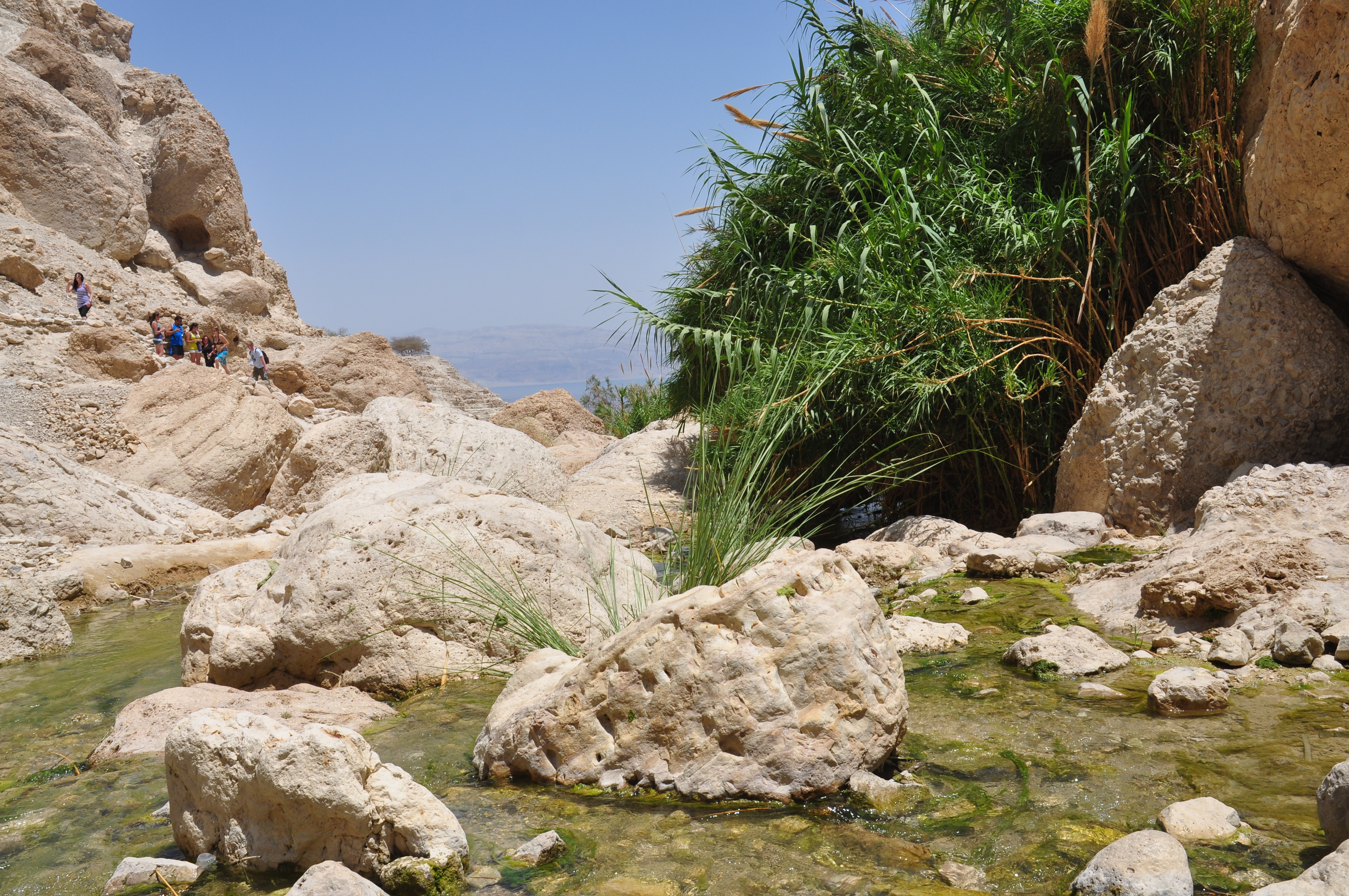
On the Mediterranean coast, 40 km north of Tel Aviv was a small, sleepy Phoenician town founded about the 3rd C BCE with a modest port called Strato’s Tower. All that changed when King Herod chose the site for the development of a large, protected harbor that could be used year round. This boosted trade and commerce (and made a lot of money for Herod) and enabled closer ties with the centers of the Roman empire. Caesarea was a well-planned urban center, a walled city with streets laid out in a grid, warehouses, a Roman temple, a large theater (the first one in Israel according to Netzer), a stadium/hippodrome, public baths and according to Josephus several palaces. There was plenty of water for the city brought by an aqueduct and later in the time of the Emperor Hadrian by a second aqueduct built by the Tenth Roman Legion. To date, only a small percentage of the city has been excavated.

In Josephus there is a detailed description of Herod’s palace, preceding even the harbor which was an exceptional feat of engineering and probably a great source of pride to Herod. Its location on a promontory jutting 100 meters out into the sea makes it another of Herod’s unique palaces. The placement of a pool in the center (where one would expect to find an internal courtyard) shows Herod’s exceptional building style. The other two natural promontories at Caesarea were used to anchor the harbor. All of the pool is hewn into the kurkar sandstone bedrock, coated with hydraulic plaster and from the outset was filled with fresh water and was intended for swimming and bathing. Evidence that pozzolana cement was used in the construction of features of the pool is further evidence that it was constructed at the same time as the harbor.

Some scholars regarded the pool as a fishpond and the entire structure a piscine, or fish market of sorts based on a network of open channels, intermediate pools and sluices linking the pool with the sea but according to Netzer this was at a later stage, 600 years after Herod when the pool was put to secondary use. Many fallen drums, pedestals and capitals were found at the bottom of the pool presumably from rows of columns that framed a peristyle courtyard. The pool is bordered on the east by the triclinium (formal dining room) and on the west by additional rooms closer to the sea. The floors of the triclinium and smaller rooms on each side had elaborate, geometric mosaic floors.

Plan of the Promontory Palace (J.H. Williams and A. Iamim): a) first phase (c. 22-15 BC) ; b) second phase (c. 15-4 BC)
From https://www.baslibrary.org/biblical-archaeology-review/19/3/7

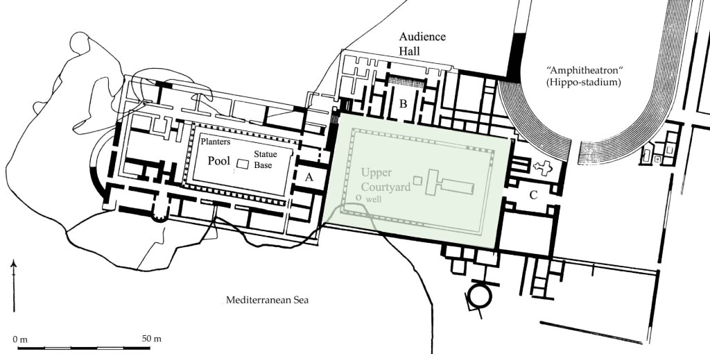
Additional excavations in 1976 followed the development of the east wing during the Roman period. Beside the triclinium was added a small caldarium, whose hypocaust and furnace were well preserved. One of the tiles of the furnace has the stamp of the Legion X Fretensis. Excavators found two inscribed marble columns with six dedicatory inscriptions that reveal important new information about officials of Caesarea from the 2nd-4th C CE.

Caesarea was battered by a strong storm in December 2010 (see Haaretz article) and 1000 year old artifacts were swept into the sea and lost forever (on my recent visit to the park I saw Park Authority staff working to cleanup the damage to the palace).

Besides the architecture there is also the human drama. Josephus describes many incidents in peoples lives that happened in Herod’s palace. Agrippa I died in the palace after opening the Games and blaspheming in the stadium (Acts 12:20-23). A hall in the Upper Palace was the destination of the apostle Paul for a hearing before Antoninus Felix (Acts 23:35.). Later, Herod Agrippa II and his sister Berenike visited a new governor, Porcius Festus, and heard Paul’s self-defense there (Acts 25:23). Josephus relates a demonstration outside of the palace demanding the removal of Roman standards with the images of humans and animals from Jerusalem. Pilate had the Jews held in the stadium and threatened to kill them but backed down. Found in secondary usage at the theater was a dedicatory inscription inscribed with the name Pilatus (there is a copy in the peristyle courtyard of the palace, the original is on display at the Israel Museum).

Madaba map

A few weeks ago I was guiding in the Old City and was explaining about the Madaba map, a graphical representation based on the Bishop Eusebius’ Onomasticon that lists cities and towns in the Holy Land during the Byzantine period. It is the oldest map we have of the area and includes a detailed map of Jerusalem. It was one of the first things that Haim Karel, who taught us in the guides course, impressed on us. It’s like having a map for buried treasure, the Madaba map shows archaeologists where to dig and guides what to guide.

Two summers ago while flying back from Nepal via Jordan we stopped in the sleepy Jordanian town of Madaba and got to see the original map in mosaic on the floor in St. Georges Church, a very special treat. I took this photo in the church.

Because Jerusalem is so important in Christianity the map includes a large and detailed depiction of Jerusalem. Note that in the Byzantine period it was customary to show north on the left (just as we show north up today). Hence, from left to right you can clearly see the Cardo running north-south from Damascus gate. In Arabic, this gate is called Bab el Amud which means the “gate of the column” because inside the gate was a plaza and a column with the statue of the emperor (today the column is gone but you can walk on the Roman flagstones of the plaza). The Madaba map shows that the Cardo joins the Church of the Holy Sepulcher, the holiest site to Christianity,  to the 5th C Nea Church of Justinian and there were religious processions along the Cardo between the two churches. Other things to notice are the gates of the city and the myriad of churches, any building with a red roof is a church: Holy Zion, Saint Sophia, Santa Anna, Siloam church.

Unusual for a Roman city there is another main north-south road, a secondary Cardo that follows the route of the Tyropean valley, part of which runs along the back of the Western Wall plaza. When plans were being made to build a visitors center for the Tunnel tour they knew that they would be building right on the secondary Cardo. What began as a salvage dig has become an important archaeological excavation. Although not yet open to the public you can view the excavation from a lookout point in the Jewish quarter.

Bird Mosaic at Caesarea

Caesarea Maritima was a city and harbor built on the ruins of Strato’s Tower by Herod the Great about 25–13 BCE. It’s a very popular site, the archaeological park lies on the Mediterranean coast of Israel about halfway between the cities of Tel Aviv and Haifa. The city of Caesarea was described in detail by the 1st century Roman Jewish historian Josephus.

The city became the seat of the Roman praefecti soon after its founding. In 1961 Italian archaeologists excavating the theater found a stone inscription with the name of Pontius Pilate, according to the New Testament the Roman Governor responsible for ordering that Jesus be put to death, the first archaeological evidence that Pilate existed.

While visiting the Herodian, Roman, Byzantine and Crusader ruins of Caesarea make sure to see the Bird mosaic, a large rectangular mosaic ‘carpet’ on the floor of an extravagant mansion first uncovered in 1950 but only conserved and viewable by the public in 2004. It’s a tapestry of the land of Israel and includes fruit trees and animals native to Israel (lion, tiger, bear, wild boar, ibex, dog, elephant, deer and bull) bordering 120 round medallions, each of which contains a different bird.

Bird Mosaic Caesarea

Bird Mosaic


The owner of the mansion is unknown but was obviously extremely wealthy. Built in the sixth century on a hill overlooking the sea, the mansion included a hall with the mosaic floor, columns, an open roofed yard and a second floor. The findings indicate an exceptionally developed water and drainage system that included inclined floors, water canals and recessed wells.

When walking through the hippodrome don’t miss the mosaic floor from a 6th century public building near the public baths with images of birds, animals and people. Interesting to compare it with the Bird mosaic above.

Roman Bath House from Herodium

One of the most exciting new installations that I saw in the Israel Museum’s renovated archaeology galleries was the display of a part of  the laconicum (hot dry room) next to the calderium of the Roman bath house that was found at Lower Herodium. I arrived to see the museum staff putting the final touches to the installation that shows clearly all the components: the hypocaust, the underfloor heating system where the floor is supported by stone pillars (pilae stacks) and the clay tubes in the walls to let the heat pass through; the plasterwork and fresco paintings on the wall; the mosaic floor.

Nearby is another square mosaic floor with a geometric, intertwined circle and pomegranates (one of the 7 species that grows in the land of Israel and characteristic Jewish motif of this period) in each of the corners. You can see this mosaic on site at Lower Herodium in the main tepidarium if you climb onto the roof of the bath house (though I learned that the one in the museum is the original and on site is a copy). If you look to the right, there is another mosaic in the small tepidarium designed as an opus sectile pattern of tiles.

I didn’t see any other artifacts from Herodium being readied for display – I was hoping to see the 3 sarcophagi that were discovered.

Mosaics at Inn of Good Samaritan

On the main highway <1> between Jerusalem and Jericho is a site identified with the Inn of the Good Samaritan (mentioned in the parable in Luke 10:25-37). Remains from the first century BCE to the first century CE were found throughout the area. Abundant finds from this period include pottery, clay lamps, glass vessels, metal implements and numerous coins attesting to intensive activity that befits an inn for Jewish and then Christian pilgrims and travelers making their way between Galilee and Jerusalem.

Byzantine artifacts

In the Ottoman period, a rectangular structure was built over the southern wall of the Crusader fortress. This building underwent numerous alterations and was restored after being damaged during WWI. It served as a roadside inn guarding the Jerusalem-Jericho road from attacks by brigands as it had for centuries.

Since the parable of the good Samaritan includes men of three faiths, the newly opened museum has chosen to display the mosaic floors and other artifacts found in churches and Jewish and Samaritan synagogues in Judea, Samaria and Gaza, you can see part of the mosaic floor of a 6th C Jewish synagogue that stood in Gaza (I even got to do some conservation work on the mosaic).

It is fascinating to see the similarities and differences among the images displayed in mosaic.

Mosaic Khirbet Huriya

The art of mosaic began in the Greek world around the 4th C BCE and reached Israel during the Hellenistic period. It continued to develop and by the end of the Second Temple and Roman periods simple, plain and geometric mosaics became more ornate, complex with representations of flora and fauna, people, instruments, religious symbols. It became the chief means of paving public buildings, private homes, bath houses, churches and synagogues.

Places Nearby

Take the cutoff to Maale Adumim to visit the Martyrius monastery (there is a combined entrance ticket; note you need to phone in advance), the largest in the Judean desert. Inside the complex the main church was paved with colorful mosaics in geometric patterns interspersed with pictures of animals; the refectory floor, discovered intact, is covered with mosaics in geometrical designs and the kitchen was also paved with mosaics.

On the opposite side of the road along Wadi Qelt visit one of Herod’s fortresses, named after his mother, Cypros. There are 2 bath houses with remains of mosaic floors.

If you are planning a trip down to the Dead Sea and Ein Gedi don’t forget to take a few minutes to check out the mosaic floor in the synagogue (your entrance ticket to the nature reserve is good for the archaeological park). The synagogue has a detailed 18 line inscription in Hebrew and Aramaic including the 12 signs of the zodiac (indicated by their names but not depicted graphically as in most other synagogues of the same period, eg. Tiberia, Bet Alfa, Tzippori). The central hall has 4 birds within a medallion, peacocks grasping a bunch of grapes, a menora and geometric patterns.

Ein Gedi

Ein Gedi-waterfalls and pools

Ein Gedi (literally Spring of the Goats, refers to Nubian Ibex that come to the spring to drink) is an oasis in the Judean desert along the western shore of the Dead Sea. Here are two hikes (each about 5 km) in the Ein Gedi reserve that are perfect for families, Nahal David and Nahal Arugot.
On entering the reserve follow the marked the path and after about 15 minutes of easy walking we’ll reach the first waterfall, Mapal Shulamit that cascades 30 meters down the rock to a pool below. After a refreshing dip we’ll continue to a fork in the trail, we’ll take the steeper one on the right (the other path would take us back to the entrance) to the Shulamit spring and from there above the wadi to the Dudim cave. Retracing our steps we’ll continue to the Ein Gedi spring and beside it the flour mill. From there we can walk to the ruins of the Chalcolithic temple (3500 BCE), one of the oldest remains of human settlement in the Judean desert. We’ll descend through a cranny along a dry canyon to discover a 50 meter high waterfall and a great view of Nahal David and the Dead Sea beyond.

Ein Gedi-Nahal DavidAccording to the Roman historian Pliny the Elder the area of Ein Gedi was settled during the Second Temple period by a Jewish ascetic sect called the Essenes. The archaeological evidence uncovered by Hirschfeld suggests that they lived   near the spring where he found more than 20 tiny stone cells and two pools, one for irrigation and one a miqve or ritual bath. Pottery shards date it to the first century BCE.

The second hike starts from Tel Goren along the Nahal Arugot river bed past acacia trees and salvadora to a large pool used for irrigation of crops like balsam; the pool was filled by a channel that brought runoff from the wadi. Continuing we will pass reeds, maidenhead ferns, willow and poplar; we may see a rare orchid called Ben Horesh. A little farther the wadi narrows to a steep walled canyon at whose end is a waterfall and pool.
Excavations at Tel Goren by Mazar of the Hebrew University in  the 1960s show that the site was settled in the Israelite period and functioned as a royal estate for growing dates of the now extinct Judean palm Phoenix dactylifera, considered uniquely medicinal. Balsam was grown for the production of perfume (in Hebrew, afarsimon).
The Romans were interested in the production of balsam perfume; Mark Anthony confiscated the groves from Herod and gave them to Cleopatra. After their deaths, Herod was able to lease them back. During the Great Revolt, the Jews uprooted the groves so they would not fall into the hands of the Romans.
Excavations have revealed a small Jewish village and a synagogue from the 4th century with a beautiful mosaic floor. Written in Hebrew and Aramaic,  inscriptions list the signs of the zodaic and months of the year (later displayed graphically in mosaic floors in synagogues in Bet Alpha and Tiberius) and the expression “Peace unto Israel” (also found in the ancient synagogue in Jericho) and a dire warning at the end: “whoever reveals the secret of the town to the Gentiles – He whose eyes range through the whole earth and who sees hiddens things, He will set his face on that man and on his seed and will uproot him from under the heavens.” The secret seems to be the production of perfume from balsam.

En Feshka pondThe other natural source of fresh water in the Judean desert is Ein Feshka 30 km to the north of Ein Gedi. The lowest nature reserve in the world consists of 3 parts of which one is closed to visitors except research scientists who are studying the desert. The public part includes a small archaeological site from the Second Temple period and pools of fresh water, picnic tables and facilities for the enjoyment of visitors. The closed reserve is 1500 dunams (370 acres) that can only be visited with an authorized guide like me. It’s incredible to find a large freshwater pond with fish, shaded by trees in the middle of the desert next to the Dead Sea.