Category Archives: Architecture

Cable over Hinnom valley

Walking along Derekh Hevron towards the Old City you pass the Mount Zion Hotel on your right. Without a guide it is doubtful that you will notice the coat of arms sculpted in the stone of the building or recognize its significance. This is the emblem of the Order of St. John, a British charitable organization dating back to the time of the Crusades. They arrived in the Holy Land in 1882 and purchased land opposite Mount Zion overlooking the Hinnom valley with the aim of establishing an eye hospital. The hospital served Muslims, Jews, and Christians from all over the Middle East until WWI.

During the war the Ottomans took over the building for use as an arms warehouse and parts of the hospital were destroyed by British shelling. An earthquake with epicenter near Jericho on July 11, 1927 damaged buildings in Jerusalem, including the hospital. British architect Clifford Holiday was in charge of the renovations of the hospital in the 1930s adding two new wings, the second on the other side of the road (today the Jerusalem House of Quality, a gallery and artists’ workshops, worth a visit). Holiday also built  the nearby Scottish Church on Ketef Hinnom and the original Jerusalem City Hall.

Without a guide it is doubtful that you would notice a box hanging on a cable from the corner of one of the buildings or understand its significance. During the Israel War of Independence the terrain and Jordanian sniper fire made it difficult to move men and supplies between the western part of the city and Mount Zion, both in Israeli hands. A tunnel was dug crossing the wadi but this only provided limited access. So in December 1948 Uriel Hefetz, an engineering corps commander at the Etzioni Brigade, conceived of the idea of stretching a 200-meter steel cable across the Hinnom Valley from a room in the hospital to the Israeli post at the Eretz Hatzvi school on Mount Zion. It was used during the night to transfer medicine and arms to Mount Zion and the wounded to the hospital. During the day the cable was lowered to the ground so it would not be discovered by the Jordanians. The cable was inclined with a maximum height of about 50 meters above the wadi. The cart that ran on the cable was just large enough for one person but could carry a weight of about 250 kilos. The original room has been made into a small museum housing the winch mechanism and other period artifacts.

Petit
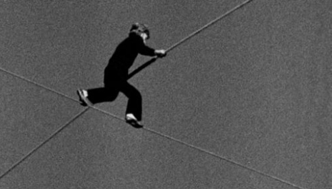
You won’t find this anecdote in any of the guide books, another advantage to hiring a guide. In 1987, Teddy Kollek, the mayor of Jerusalem invited the French high-wire performer, Philippe Petit (earlier, on August 7, 1974 Petit had walked between the Twin Towers of the World Trade Center in New York City), to walk the inclined cable across the Hinnom valley as part of that year’s Israel Festival. The performance,  A Bridge for Peace, drew a crowd of 50,000 people from all parts of the city who stood in amazement. An Israeli, Uri Dromi wrote an Op-Ed piece in the December 16, 2009 edition of the New York Times where he reminisces about watching Petit.

This was just few months before the first Intifada, but the excited crowd that gathered there on a sunny day had no clue of the lava ready to erupt below. Their eyes were glued onto the brave Frenchman and they held their breath for an agonizingly long time until he finally touched the safe ground on the other side.

From the hotel you look across the Hinnom valley at Mount Zion, the Arab-Jewish neighborhood of Abu Tor and the Arab villages on the surrounding hills.

“This was a very important memory for me,” said Petit. “That’s what the wire can do, when you link two mountains, you link the people who live on those mountains.”

Kathisma Church

Aerial photo of Kathisma site, IAA

Despite the many people traveling along the main road to Bethlehem (or Gilo or Gush Etzion) before the turnoff to Har Homa and Herodium few notice the ruins of a 5th century Byzantine church and monastery. Discovered by chance in 1992 when the road was paved and excavated briefly in 1999 by Rina Avner, the site is worth exploring but lies abandoned due to lack of money, time and initiative. Called the Kathisma church, after the word in Greek for seat (καθισμα), according to Christian tradition it is where Mary rested on the way to Bethlehem just before giving birth to Jesus.

Most Byzantine churches are in the shape of a basilica, a rectangular plan with a central nave and two aisles, with a semicircular apse at the far end. Not exactly a church, the Kathisma is a martyrium, a special structure that functions as a church (or mosque) and marks the site of a holy event. Rather than a basilica, the church is octagonally shaped and built over a flat, protruding rock in the center. There are 3 concentric octagons, the innermost one around the rock, the second a walkway (ambulatoria) with one chapel and the outer one made up of 4 chapels and smaller rooms.

The floors are covered in mosaics in geometric and floral designs in white, black, yellow, green and red stone tesserae. The mosaics have been mostly covered with felt mats and sand to protect them.

Kathisma palm mosaic from Arab period, IAA

One of the finest mosaics is from the Arab period, an ornate mosaic of a date palm in the southeastern corner. According to the Koran, Mary sat and rested under a palm during the onset of her labor.

There are ruins of another octagonally shaped church at Capernaum. The remains of a 5thC church were uncovered that consist of a central octagon with eight pillars, an exterior octagon with thresholds still in situ, and a portico. Later an apse with a pool for baptism was constructed in the middle of the east wall. The central octagon was placed directly on top of the walls of Simon Peter’s house with the aim of preserving its exact location.

The floor of the portico is a geometric patterned mosaic. In the area of the external octagon, the mosaics represented plants and animals in a style similar to that found in the Basilica of the Heptapegon at Tabgha. In the central octagon, the mosaic was composed of a strip of flowers, a field of fish with small flowers and a circle with a peacock in the center.

Another church that is octagon-shaped and crowned by a copper dome though enclosed in a rectangular envelope is the church on the Mount of Beatitudes. The church is from 1938 and was designed by the Italian architect Antonio Barluzzi in neo-Renaissance (Byzantine) style.

He chose the octagonal shape to match the eight beatitudes from the Sermon on the Mount (Matthew 5:1-5) and on the eight stained glass windows beneath the dome are verses from the Sermon.

There are only a couple of other churches that have been built over a rock, the Basilica of the Agony and the Basilica of the Heptapegon but neither is an octagon.

According to our understanding the Kathisma church was renovated in the 6thC and used as a mosque in the 8thC after which it was destroyed. A mihrab, or prayer niche facing Mecca was built into the southern wall of the outermost octagon. This means that the church was not destroyed during the Persian conquest and existed at the time of Abd el-Malik who commissioned the building of the Dome of the Rock, a martyrium in octagon shape over a rock – it may have been the inspiration for what has been called the earliest example of Islamic architecture.

Dome of the Rock

When viewing the Old City skyline probably the most striking sight is the gold dome of the Dome of the Rock. The Umayyad Caliph Abd el-Malik had this shrine built like a Byzantine martyrium, octagonal in shape, in 691CE over a rock on the Temple Mount.

Dome of the Rock ~1934, Matson collection

Over the years various metal coverings have been tried on the dome. In 1993 King Hussein of Jordan donated $8.2 million to cover the dome with a layer of  gold, 80kg in total. In Muslim tradition the rock is the place where the prophet Mohammed ascended to heaven on his Night Journey. The platform is called the Haram el-Sharif, the Noble Sanctuary.

In Jewish tradition the rock is the foundation stone from which the whole world was created, where later Abraham was commanded to go and sacrifice his son Isaac. King David purchased the area from Araunah the Jebusite who was using it as a threshing floor (2 Samuel 24) and built an altar there marking the place where Solomon built the First Temple. The platform was extended by King Herod in 20BCE while renovating the Second Temple.

There is a special feeling on the Haram el-Sharif, away from the hustle of the Old City – you can feel a lot of history there. While most of the buildings are Islamic there are remnants of Crusader architecture and even capitals from the Byzantine period, Roman marble columns and a sarcophagus (check out the similarity to the one discovered at Herodium). The First and Second Temples stood for 1000 years on this site. It is important to understand the centrality of the Old City of Jerusalem to Judaism, Christianity and Islam.

The other day I visited the Haram el-Sharif in the early morning light. I passed through the airport-like security by the Western Wall plaza and walked up the wooden ramp that leads to the Mugrabi gate and shot these photos. Click on an image below to view it full-size. I’d be interested in hearing your comments.


Not in Herod’s Lifetime

Just came back from a press conference with Ronny Reich, archaeologist and professor at Haifa University. Probably every guide talks about the Western Wall, the supporting wall of the Temple Mount built by King Herod in 22BCE. According to the historian Josephus, Herod elongated the square Hasmonean platform (250 meters by 250m) by rebuilding new northern, western and southern supporting walls. The eastern wall was extended and the “seam” between the earlier Hasmonean wall and Herod’s can be seen near the south-eastern corner. Along the western wall Herod designed a main street (Ronnie Reich calls it the original Wall Street, the Palestinians probably call it occupied) and a vault supporting a large staircase crossing over the street and leading to the Royal Stoa, a building 288 meters long with 160 columns (it takes 3 people with arms extended to go around a single column). When Herod moved the western wall he had to move some residences that were in the way, at the bottom of the slope from the Western Hill. These buildings were destroyed but the basements, underground cisterns and mikvaot (ritual baths) were just filled in with debris/earth. One mikva directly under the path of the planned western wall, was filled in and covered with 3 large stones. In clearing out the drainage channel under Robinson’s Arch, the mikva was discovered under the Herodian stones of the western wall.

Some clay oil lamps and a small pottery jug typical of the Second Temple period were found.

When the mikva was emptied and the soil sifted 19 coins were found, the latest ones were from the rule of Valerius Gratus, the Roman Prefect (governor) of Judaea province under Tiberius from 15 to 26CE. He was succeeded by Pontius Pilate.


Reich said four small bronze coins were found with dates of 15CE and 16CE (IAA press release says 17 coins with dates of 17/18CE). Since the coins were found in the fill in the mikva under the wall, the first (lowest) row of stones in the wall must have been placed there after 16CE so the wall was built more than 20 years after the death of Herod (who died in 4BCE). If that is the case, then the Herodian street, the staircase and probably the Royal Stoa were all later additions, not completed in Herod’s lifetime!

By the way, these stones have the frame but were left with the boss (protuberance) since they were underground and would never be seen.

This confirms Josephus’ account in the last book of Jewish Antiquities that the Temple building project was the largest project the ancient world had ever heard of and was not completed until about 50CE in the rule of King Agrippa II, Herod’s great grandson (even though some 15-18,000 workers were employed on the project).

Photo Walk

I spent 3 hours yesterday afternoon on a photowalk, in this case, walking through the Old City taking photos, one of about 30 photographers. We started at Kikar Tzahal, walked through the Mamilla mall, entered Jaffa gate, followed the main road through the Armenian quarter to the Jewish quarter, down the steps to the Western Wall plaza and back to Jaffa gate via the Arab shuq. The route was chosen by a photographer – I think a guide could have taken people to some places that would have been more interesting to shoot. I was hoping for some photos with a background sky with a pink and blue sunset but the weather just didn’t cooperate yesterday.

In this post I’m sharing what I think are my best 7 photos. It gives you one particular view of Jerusalem on a particular day. A photowalk is an interesting photographic exercise.

The first day that you could ride Jerusalem’s new Light Rail was August 19. I rode it for the first time last week with clients. For the time being it’s free.

One of Jerusalem’s newest and fanciest hotels designed by Israeli architect, Moshe Safdie, as part of the Mamilla project. Across the street is the David Citadel Hotel also designed by Safdie. On the opposite corner the new Waldorf-Astoria is being built which incorporates the original Palace Hotel.

A really incredible flower shop, Aleh Koteret, with Jerusalem being reflected in the window.

The juxtaposition of metal and Jerusalem limestone, old and new.

Crossing through the Armenian quarter, you take an alleyway that turns left and under an arch is a view north to the Christian quarter and the Church of the Holy Sepulcher and the Mosque of Omar (Ibn Khattab). But Jerusalem, even the Old City, is not a living museum, so there are also water tanks, dude shemesh (sun heated water panels) and satellite dishes.

I can only submit one of these photos to the competition. Comment to make your choice.

Jerusalem Tombs

With a history that goes back 4000 years, you can find a lot of tombs in and around Jerusalem. I’ve already blogged about Nicanor’s tomb, tombs at Ketef Hinnom, Caiaphas tomb, Mary’s tomb – you can see all the articles by clicking on Tombs in the right hand column under Categories. Todd Bolen posted a link to a Jerusalem Post article about some significant Jerusalem tombs, King David’s tomb, a Mamluk tomb, Herod’s so-called family tomb (Herod himself chose to be buried at Herodium – one of my favorite sites to guide) and Jason’s tomb and suggested that a couple of photos would enhance the article. I’m happy to oblige and I even mapped out the sites on Google Maps to make them easier to find.