Phoenician Glass-blowing to Chihuly

Glassblowing is a glass forming technique which was invented by the Phoenicians in about 50BCE along the Syro-Palestinian coast. The earliest evidence of glassblowing comes from waste from a glass workshop, including fragments of glass tubes, glass rods and tiny blown bottles, that was dumped in a mikveh (ritual bath) in the Jewish Quarter dated to the time of King Herod, from 37 to 4BCE.

During excavations in the Jewish Quarter by Avigad and Geva in the 1970s they discovered in the eastern wall of the Fresco room (F3) in the Palatial Mansion a niche in which was standing a glass jug by the 1st C artist Ennion of Sidon with his name in Greek on the vessel. This rare piece can be seen as part of the glass collection in the Israel museum’s archaeology wing. The buildings, with mosaic floors and frescoes, have been preserved in the Wohl museum and are worth a visit.

If you are interested in glass-making it is also worth checking out the Glass Pavilion at the Eretz Israel museum in Tel Aviv which exhibits ancient glass vessels, representing 3 chapters in the history of glass production:

  1. Pre-blown glass
  2. Blown glass from Roman/Byzantine period (they also have one of Ennion’s works, Blue Jug)
  3. Blown glass of Islamic period

Currently (January 2011) there is a gold-glass panel (table top) with mosaic-glass tiles found in the Byzantine “Birds Mosaic” mansion in Caesarea on display in Israel for the first time. Both museums collect and exhibit contemporary glass art.

Some of the earliest pieces of blown glass have been discovered in Israel and the tradition of glass blowing developed in this area but since then there has been little activity in glass art. Only in the the mid 1970s with Marvin Lipofsky’s visit to Israel was there an opportuity to try glass making. Lipovsky built the first glass furnace for the Ceramics department at the Bezalel Academy of Art in Jerusalem, the first courses were taught in the late 70s but a formal department with a full curriculum was established only in 1997. The glass furnace built by Lipofsky over 35 years ago is the same furnace in use today and to date Bezalel remains the only university where students can study glass making in Israel.

In 1962 Dale Chihuly, a 21 year old American, came to Israel and volunteered on Kibbutz Lehav north west of Beersheva in the Negev.

I discovered there was more to life than having a good time,” he has said of his kibbutz service. “It’s difficult to explain how this change came about, but it had a lot to do with going out on border patrol during the night with guys my own age who had more responsibility and maturity than adults twice their age in the States.

Chihuly credits this Israel experience as the turning point in his life. He recalls that he began to think of how he could make a contribution to society. He became dedicated to the hard work and long hours necessary to realize his goals. Conceivably, the collective nature of kibbutz life also inspired him to work with a close-knit group of artisans for a common purpose, the creation of art.

Chihuly’s choice of a millennium project was his famous installation at the Tower of David Museum inside Jaffa Gate in 2000, a project that proved to be “history-making in its ambition, its difficulty and its enormous popular success”. The Light of Jerusalem 2000 installation was composed of 10,000 pieces of individually hand-blown glass weighing a total of 42 tons, the various elements of the work were shipped to Israel in 12 40-foot containers from five different countries. I was one of more than a million people who saw his work.

The installation was the fruit of Chihuly’s relationship to Israel and to the history of blown glass. Chihuly was aware that two thousand years ago, some of the oldest glass in the world had been made in Jerusalem and that just before the birth of Jesus, glassblowing was invented. Israeli artists say that Chihuly’s exhibit was an eye-opening experience and defining moment for them so like Israel affected Chihuly, he affected Israel.

Chihuly at Tower of DavidIf you’re interested in glass art check out the Litvak Gallery in Tel Aviv near the Gallery of Art for their current exhibition. They have works by Chihuly as well as other contemporary glass artists. There was a special Chihuly exhibit in January 2011.

Earthquakes in History and Archaeology

Israel and Jordan lie along the African Rift, that runs from the heart of Africa through the Red Sea, Dead Sea and Jordan River valley, the deepest known break in the earth’s crust. The rift was formed by adjacent continental plates. As the plates move, stress accumulates gradually which is relieved periodically through sudden jolts, experienced as an earthquake. There are many events in the Bible that can be explained by major earthquakes. The destruction of Sodom and Gomorrah on the eastern shore of the Dead Sea in the time of Abraham about 1900BCE is vividly described (Genesis 19). Archaeological research suggests that a great earthquake opened the earth’s crust releasing “brimstone” (sulfur) and volatile petroleum gases which caused a horrific firestorm. The fall of Jericho in 1400BCE was probably associated with a double earthquake. As Joshua and the children of Israel crossed the Jordan River to enter the land, an earthquake-produced landslide at the town of Adam (15 miles to the north) dammed the Jordan.  Historically known quakes have dammed the Jordan River repeatedly, sometimes for several days, in 1160CE, 1267, 1534, 1834, 1906 and 1927. Then God arranged a second tremor, or aftershock, to topple Jericho’s walls (Josh. 6). A major earthquake is reported “in the days of Uzziah king of Judah, and in the days of Jeroboam son of Joash king of Israel” (Amos 1:1), sometime between 760BCE to 749BCE. Geologists believe they have found evidence of this major earthquake in sites throughout Israel and Jordan:

“Masonry walls best display the earthquake, especially walls with broken ashlars, walls with displaced rows of stones, walls still standing but leaning or bowed, and walls collapsed with large sections still lying course-on-course. Debris at six sites (Hazor, Deir ‘Alla, Gezer, Lachish, Tell Judeideh, and ‘En Haseva) is tightly confined stratigraphically to the middle of the eighth century BCE, with dating errors of ~30 years.…The earthquake was at least magnitude 7.8, but likely was 8.2…This severe geologic disaster has been linked historically to a speech delivered at the city of Bethel by a shepherd-farmer named Amos of Tekoa.”

Qumran
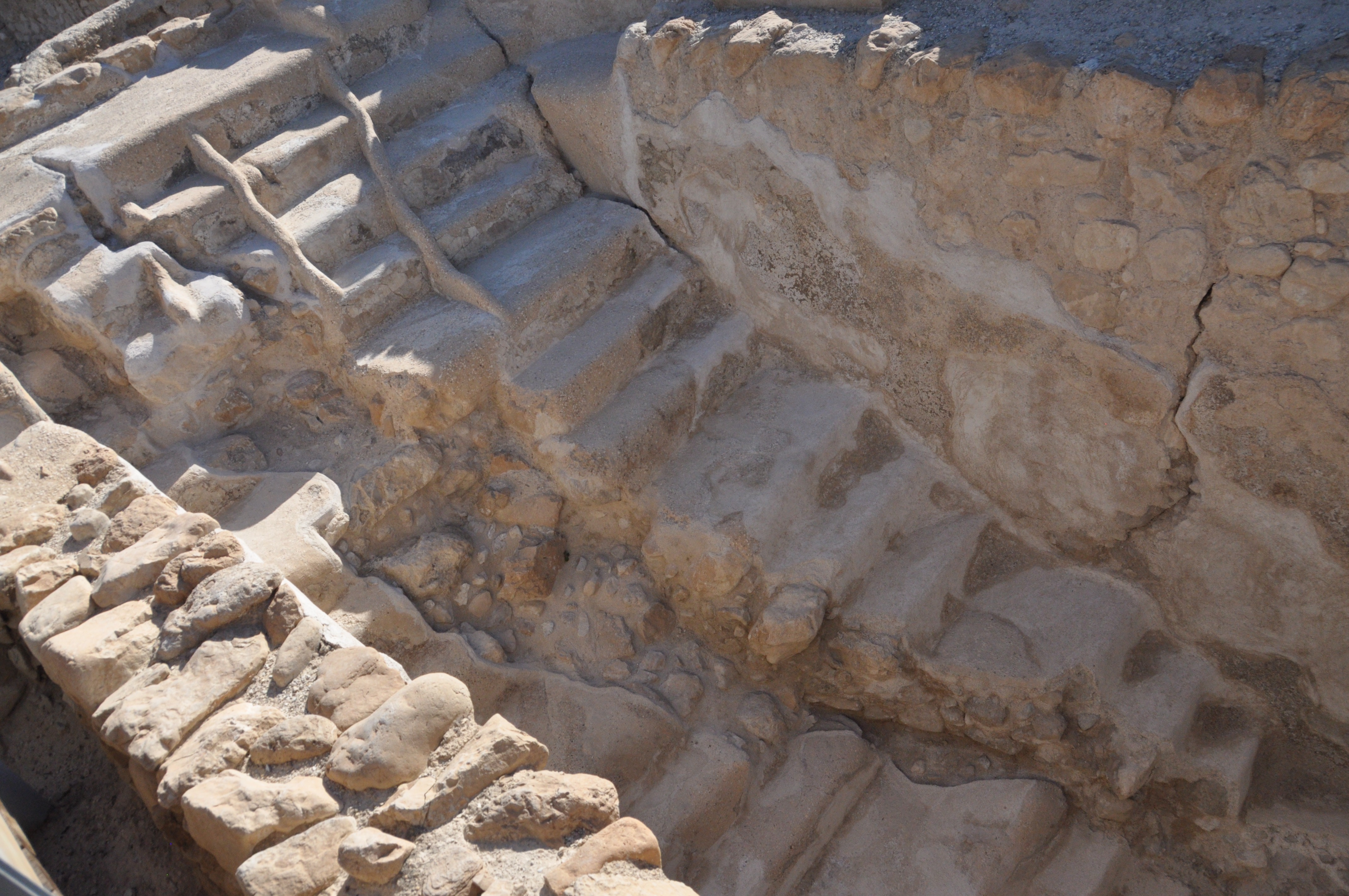
Qumran, where the Dead Sea scrolls were found, bears unmistakable evidence of major earthquake destruction in 31BC during the reign of Herod the Great where 10,000 people lost their lives (Josephus). Photo shows staircase to mikve (ritual bath) damaged by seismic activity.

When Jesus died on the cross, the end of his life was punctuated by a severe earthquake, following a strange three-hour darkness covering the land (Matt. 27:50-54) and a second great earthquake occurred on Easter morning at the time of the resurrection (Matt. 28:2). Researchers know that there was an earthquake on April 11, 33CE making it a possible date for the crucifixion. The prevalence of earthquakes during the Second Temple period caused the High Priest when he went into the Holy of Holies on Yom Kippur to include in his prayer a special intention (kavana) that the people who lived on the Sharon plain (a populated area to this day) should be spared the fate of “having their houses become their graves” (Yoma 5b).

A powerful earthquake (7.0 on Richter scale) in 363CE, which caused widespread havoc throughout ancient Israel, destroyed Antipatris (Tel Afek) and Tzippori.

Bet Shean, one of the major Roman cities known from Hellenistic times as Scythopolis, suffered major damage in 363CE and was devastated in the Golan earthquake (6.6 on Richter scale) on January 18, 749CE and never recovered. Photo from the archaeological site at Bet Shean shows toppled columns in a row along the Decumanus, think of a tablecloth jerked under wine bottles. Also on the northeastern side of the Sea of Galilee the other Decapolis city of Sussita and the nearby monastery at Kursi were destroyed and abandoned.

Jerusalem suffered a severe earthquake (6.7 on Richter scale) January 15, 1546: the dome on the Church of the Holy Sepulcher was completely destroyed as were many other buildings. The Dome of the Rock was seriously damaged; the Al-Aqsa Mosque was damaged or destroyed in 749CE, 1033CE, 1546CE and in the 1927 earthquake. The three most destructive earthquakes in Israel since the 18th century happened in 1759, 1837 and 1927. Check out my article about the Nimrod fortress to see a photo of the result of earthquake activity. On January 1, 1837 at 2pm an earthquake “obliterated” Safed, Tiberias and damaged neighboring Arab villages causing more than 5,000 fatalities. Another major quake (6.4 on Richter) occurred on July 11, 1927 at about 16:00 local time. The epicenter of the earthquake was on the western shore of the Dead Sea (31.6, 35.4) just north of Metsoke Dragot. Besides Jerusalem, the cities of Ramle, Tiberias and Nablus were heavily damaged and at least 500 people died. In Jericho, a number of houses collapsed, including several relatively new hotels. In addition, the Allenby Bridge collapsed and the Jordan river was blocked for about 21 hours following the collapse of the marl cliffs on its banks.

Earthquake in Jericho, 1927.  Photo: Matson collection.
Jericho, 1927 earthquake, by American Colony photographer

The last major earthquake to hit Israel was 1927 and on average, there is an earthquake approximately every 80 years. That and the large amount of unrelieved stress (~10 meters) along the African Rift today tells scientists that we are overdue for a major earthquake.

Archaeological Ruins at Cypros

The site of Cypros above Wadi Qelt occupies a commanding position overlooking the Jerusalem-Jericho highway and a spectacular view of the Jericho Plain and the Dead Sea (a good place to take photographs). Originally a Hasmonean fortress, Pompey destroyed it in 63 BCE and King Herod rebuilt it as a palace-fortress and named it for his mother, as recounted by Josephus. After 1967 the Israeli army used it as an outpost of bunkers, today it lies deserted.

In 1974 Netzer and Damati did preliminary excavations and then left it in ruins. Cypros consists of 2 parts – a palace-fortress on the mountaintop and additional buildings 30 meters below the summit (perhaps Herod got the inspiration for the palace-fortress at Herodium from this site). It’s a short hike from the parking lot entrance to St. George’s monastery in Wadi Qelt to Cypros.

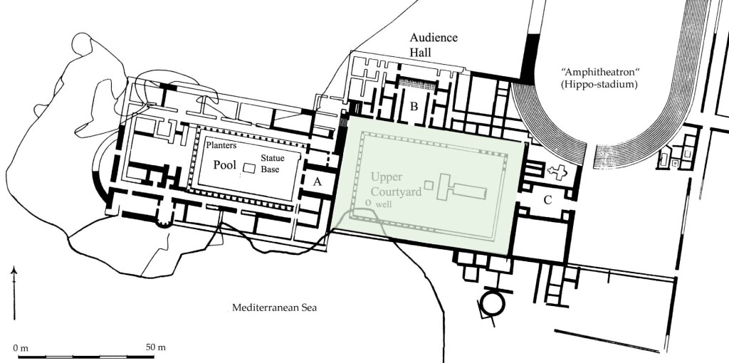
The ruins are not in good condition but there is something special to exploring a site the way an archaeologist might see it as opposed to a site that has been prepared for visitors. The remains of 2 bathhouses are still exposed, one on the mountaintop and the other below that suggest the grandeur of the site in Herod’s time. The remains of a simple white mosaic floor and pieces of plaster with red and yellow from the wall frescoes and the stone pedestals from the hypocaust floor of the calderium can be seen. There are also some sections of columns, one with some of the original plaster.


Click on the above thumbnail photos to see larger images.

Beside a mikve (ritual bath) the most unusual element found in situ, is a large stone bathtub – today its position is marked by a concrete recess, the bathtub is at the Rockefeller museum.

Down below in the bathhouse pieces of ceramic pipes that were attached to the walls of the calderium and broken ceramic discs that were piled one on another to hold up the hypocaust floor can be seen.

Walking around the site I came across a few broken pieces of terra sigillata (the first examples that I’ve found at an archaeological site), a type of fine, red-gloss Roman pottery that would have been imported from Italy or Gaul, additional evidence of Herod’s grand lifestyle.

Rosh HaNikra – Cliffs and Grottos

Geography

The chalk cliffs of Rosh HaNikra (Head of the Grottos: 33°5′35.24″N 35°6′17.16″E) along the Mediterranean coast mark the border between Israel and Lebanon. The cliffs are a unique geological formation in Israel, made of soft chalk, they descend from the ridge into the sea without an intervening section of beach, consequently they block and hinder movement along the coast.

The cliff consists of 3 layers of rock from the Cenoman period 100 million years ago:

  1. the bottom layer is hard limestone, most of which is under the sea,
  2. the middle layer reaching a height of 70 meters is soft chalk with dark flint and fossils embedded in it,
  3. the top layer is hard chalk and dolomite, similar to limestone.

The grottos are cavernous tunnels started by geological and biological  processes: cracks in the rock formed when seeping rainwater made small caves; duckweeds and other microorganisms on the soft chalk cause it to crumble. Crashing waves took over (with an estimated power of 250 tons per square meter during winter storms) and over thousands of years eroded the soft chalk to form the grottos.

History

Alexander the Great in 323 BCE passed this way, then the Selucids and Ptolemies and later the Arabs, then the Crusaders. The British army cut a road for vehicles during WWI; in 1943 they blasted three tunnels through the cliff joined by a bridge over the grottos so trains could carry soldiers and supplies between Cairo and Istanbul. On the nights of June 16 and 17, 1946, under cover of darkness and cloudy weather, the Carmel unit of the Haganah blew up the bridge during the operation Night of the Bridges. In one night the Haganah destroyed eleven bridges linking Palestine to the neighboring countries Lebanon, Syria, Jordan and Egypt, immobilizing transportation and a blow to British prestige. Twelve days after the attack the British authorities retaliated by imposing a curfew on Jewish communities and launching a security operation known as Operation Agatha or Black Saturday. With the involvement of 100,000 British troops they arrested 2,700 Jews, including many in senior leadership positions. In addition the British confiscated important papers about the Jewish underground which were taken to military headquarters at the King David Hotel in Jerusalem. On July 22, 1946, the Irgun in consultation with the Haganah bombed the King David Hotel. When the telephone warnings went unheeded and the hotel was not evacuated, 92 people were killed and the southern wing of the hotel destroyed.

Rosh Hanikra was the site where in 1949 Israeli and Lebanese officials signed an armistice agreement ending the War of Independence.

In the past, the only access to the grottos was from the sea and experienced divers were the only ones capable of visiting. In 1968, a tunnel was hewn into the cliff to give access to the grottos and then a cable car, “the steepest in the world” was installed to take visitors up and down. If you like cable cars, try to ride the other 3 in Israel, at Masada, Menara cliffs and from Bat Galim up to Stella Maris – all have great views (so don’t forget your camera)!

There is also a promenade along the shore that follow the British railroad tracks, through the Rosh HaNikra nature reserve to the Betzet beach, where every year giant sea turtles lay their eggs. Along the way, you can see some pools that the Phoenicians quarried and used to evaporate seawater to get salt,  grow snails for the blue techelet and purple dyes and as wine vats.

Caesarea-Maritima, Herod’s Promontory Palace

On the Mediterranean coast, 40 km north of Tel Aviv was a small, sleepy Phoenician town founded about the 3rd C BCE with a modest port called Strato’s Tower. All that changed when King Herod chose the site for the development of a large, protected harbor that could be used year round. This boosted trade and commerce (and made a lot of money for Herod) and enabled closer ties with the centers of the Roman empire. Caesarea was a well-planned urban center, a walled city with streets laid out in a grid, warehouses, a Roman temple, a large theater (the first one in Israel according to Netzer), a stadium/hippodrome, public baths and according to Josephus several palaces. There was plenty of water for the city brought by an aqueduct and later in the time of the Emperor Hadrian by a second aqueduct built by the Tenth Roman Legion. To date, only a small percentage of the city has been excavated.

In Josephus there is a detailed description of Herod’s palace, preceding even the harbor which was an exceptional feat of engineering and probably a great source of pride to Herod. Its location on a promontory jutting 100 meters out into the sea makes it another of Herod’s unique palaces. The placement of a pool in the center (where one would expect to find an internal courtyard) shows Herod’s exceptional building style. The other two natural promontories at Caesarea were used to anchor the harbor. All of the pool is hewn into the kurkar sandstone bedrock, coated with hydraulic plaster and from the outset was filled with fresh water and was intended for swimming and bathing. Evidence that pozzolana cement was used in the construction of features of the pool is further evidence that it was constructed at the same time as the harbor.

Some scholars regarded the pool as a fishpond and the entire structure a piscine, or fish market of sorts based on a network of open channels, intermediate pools and sluices linking the pool with the sea but according to Netzer this was at a later stage, 600 years after Herod when the pool was put to secondary use. Many fallen drums, pedestals and capitals were found at the bottom of the pool presumably from rows of columns that framed a peristyle courtyard. The pool is bordered on the east by the triclinium (formal dining room) and on the west by additional rooms closer to the sea. The floors of the triclinium and smaller rooms on each side had elaborate, geometric mosaic floors.

Plan of the Promontory Palace (J.H. Williams and A. Iamim): a) first phase (c. 22-15 BC) ; b) second phase (c. 15-4 BC)
From https://www.baslibrary.org/biblical-archaeology-review/19/3/7

Additional excavations in 1976 followed the development of the east wing during the Roman period. Beside the triclinium was added a small caldarium, whose hypocaust and furnace were well preserved. One of the tiles of the furnace has the stamp of the Legion X Fretensis. Excavators found two inscribed marble columns with six dedicatory inscriptions that reveal important new information about officials of Caesarea from the 2nd-4th C CE.

Caesarea was battered by a strong storm in December 2010 (see Haaretz article) and 1000 year old artifacts were swept into the sea and lost forever (on my recent visit to the park I saw Park Authority staff working to cleanup the damage to the palace).

Besides the architecture there is also the human drama. Josephus describes many incidents in peoples lives that happened in Herod’s palace. Agrippa I died in the palace after opening the Games and blaspheming in the stadium (Acts 12:20-23). A hall in the Upper Palace was the destination of the apostle Paul for a hearing before Antoninus Felix (Acts 23:35.). Later, Herod Agrippa II and his sister Berenike visited a new governor, Porcius Festus, and heard Paul’s self-defense there (Acts 25:23). Josephus relates a demonstration outside of the palace demanding the removal of Roman standards with the images of humans and animals from Jerusalem. Pilate had the Jews held in the stadium and threatened to kill them but backed down. Found in secondary usage at the theater was a dedicatory inscription inscribed with the name Pilatus (there is a copy in the peristyle courtyard of the palace, the original is on display at the Israel Museum).

Blogging and Guiding

Just got in from guiding, 4 days guiding this week. Shabbat comes in in an hour.

Last day of the year, a good time to take a moment to review what has been accomplished. It also marks 3 years that I have been guiding and blogging. My first clients were referred by a friend in Boston. The grandfather was the initiator of the family trip which included his wife, his daughter and son-in-law and their 2 children and the inlaws, in honor of his grandson’s bar mitzva. Since then I guided the son-in-law and 2 business associates, Texas oil men when they were here on business and will be guiding the grandfather and friends in January. My most recent client had to reschedule to today when her flight out of Newark was cancelled by heavy snow. Meanwhile weather in Israel has been mild, temperatures in the 60s (dropping now to 50s) and little rain.

I’ve written 86 articles and I’ve built a modest website which has 14 pages. From only 4 page views per day in the first year, a total of 1384 I increased to 42 page views in year 2, a total of 15,211. This year is up another 57% to an average of 65 page views per day, a total of 23,889. In the last 2 months I’ve been averaging more than 95 page views a day so people are reading my posts. This is thanks mostly to other bloggers who have linked to me so thank you Todd, Jan Pieter, Carl and others for your help. See everyone in the new year.