Category Archives: Hiking

Israel Trail Encounter

The Israel Trail or Shvil Yisrael is a national hiking trail inaugurated in 1994 that zigzags the entire country from Tel Dan in the north near the Lebanese border to the southernmost tip of Israel at the Red Sea, approximately 940 km. You may have seen sections of the trail on other hikes (the Israel Trail was created by connecting some of the existing, favorite hiking trails), for example, if you’ve visited the Small Makhtesh from the western lookout point the trail descends and crosses to the mouth of the makhtesh and then north via Maale Hatzera. You can recognize the trail by its 3 colored stripes, white (signifying the snow on Mount Hermon, north), blue and orange (like sand or south to Eilat).

I have Zvi Gilat’s excellent guidebook to the Israel Trail in Hebrew; there is one guide book, Israel National Trail by Jacob Saar, including topographical maps in English. The official website is at http://www.israelnationaltrail.com/ which includes a forum that enables you to connect with other hikers to discuss the trail.

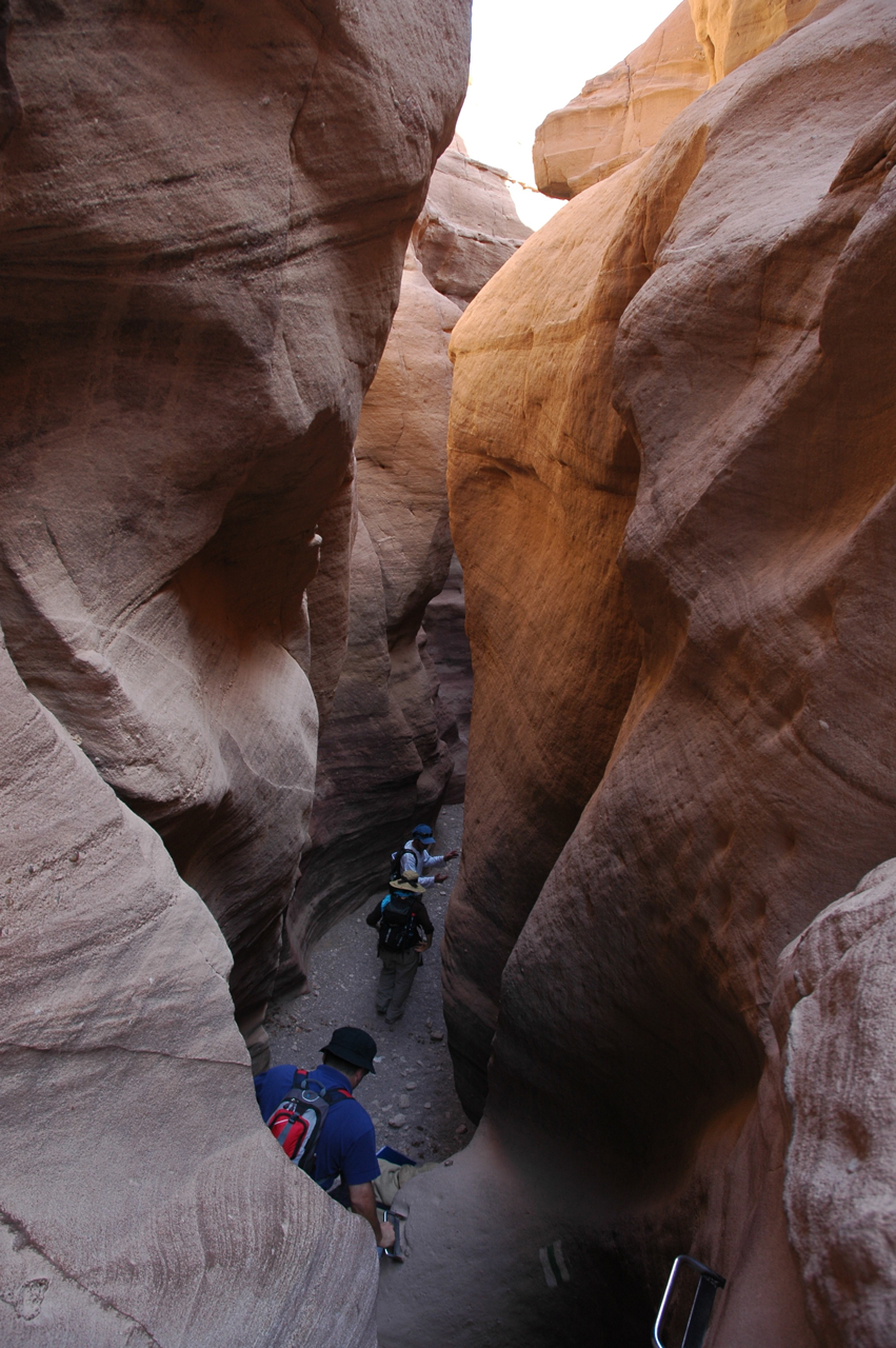
I just got back from 8 days hiking on the southern part of the trail from the border crossing with Egypt at Taba to Shaharut in the Negev (incommunicado with the outside world, walking the desert landscape – which is why there was no blog post). Walking for a number of hours through a narrow canyon, climbing a ridge or mountain for a 360 degree view of your surroundings and watching the changing forms of the sandstone cliffs as you hike by is a different experience than driving up to a site by car.

The trail lets you experience nature throughout Israel with the opportunity to relate to the history of the country. I joined the annual Avi B’shvil Yisrael, an incredible project that brings together a third component, encounter with Israelis from throughout the country, young and old, religious and secular. There is a daily group discussion about the significance of kibbutz and an evening guest who talks about his/her experience related to kibbutz (the subject being examined this year). They also handle a lot of the logistics, you can pay 10NIS for fresh fruit, vegetables and bread to have for lunch and 10NIS for a communal dinner, the organizers ensure that there is enough water for the next day, provide a guide and arrange transportation (back to where you left your car, car pooling or a main road where you can get a bus). They are hiking the Israel Trail until Thursday, April 28, 2011 when they reach She’ar Yeshuv so if you can find the time, check out the itinerary at http://www.avi-beshvil-israel.org.il/luz.php and join them. I strongly recommend it.

The project is in memory of Avi Ofner and 72 other soldiers who died on February 4, 1997 when two IDF Sikorsky CH-53 helicopters collided in midair over She’ar Yashuv. The helicopters were hovering waiting for clearance to cross the border into Israel’s “security zone” in Lebanon.

For recommendation on some dozen other hikes, click on “Hiking” under Categories in the right hand column or https://israeltours.wordpress.com/category/hiking/

Archaeological Ruins at Cypros

The site of Cypros above Wadi Qelt occupies a commanding position overlooking the Jerusalem-Jericho highway and a spectacular view of the Jericho Plain and the Dead Sea (a good place to take photographs). Originally a Hasmonean fortress, Pompey destroyed it in 63 BCE and King Herod rebuilt it as a palace-fortress and named it for his mother, as recounted by Josephus. After 1967 the Israeli army used it as an outpost of bunkers, today it lies deserted.

In 1974 Netzer and Damati did preliminary excavations and then left it in ruins. Cypros consists of 2 parts – a palace-fortress on the mountaintop and additional buildings 30 meters below the summit (perhaps Herod got the inspiration for the palace-fortress at Herodium from this site). It’s a short hike from the parking lot entrance to St. George’s monastery in Wadi Qelt to Cypros.

The ruins are not in good condition but there is something special to exploring a site the way an archaeologist might see it as opposed to a site that has been prepared for visitors. The remains of 2 bathhouses are still exposed, one on the mountaintop and the other below that suggest the grandeur of the site in Herod’s time. The remains of a simple white mosaic floor and pieces of plaster with red and yellow from the wall frescoes and the stone pedestals from the hypocaust floor of the calderium can be seen. There are also some sections of columns, one with some of the original plaster.


Click on the above thumbnail photos to see larger images.

Beside a mikve (ritual bath) the most unusual element found in situ, is a large stone bathtub – today its position is marked by a concrete recess, the bathtub is at the Rockefeller museum.

Down below in the bathhouse pieces of ceramic pipes that were attached to the walls of the calderium and broken ceramic discs that were piled one on another to hold up the hypocaust floor can be seen.

Walking around the site I came across a few broken pieces of terra sigillata (the first examples that I’ve found at an archaeological site), a type of fine, red-gloss Roman pottery that would have been imported from Italy or Gaul, additional evidence of Herod’s grand lifestyle.

Red Canyon

Rather than driving all the way down to Eilat on highway 90 you might want to consider a detour, taking a right onto highway 13 and then a left onto 40 which follows the Israel Trail. After 38 km you’ll come to Shizaphon Junction where you’ll find an organic, vegetarian restaurant run by the folks of Kibbutz Naot Smadar, a lovely place to take a break.

At the Pundak you can also buy products from the kibbutz, artisan goat cheeses, bread, jams, fruit leather, dates and wine – everything you’d need for a picnic. I highly recommend that you try their goats yoghourt ice cream with the homemade apple cake. Mmmm, delicious.

From the junction if you continue on highway 40 you’ll come to the kibbutz itself, like a magical kingdom appearing out of the desert. Many of the kibbutznikim are artists and they’ve built a studio space and gallery that you can visit.

Afterwards retrace your steps and take highway 12. After about 3 km there will be a dirt road to your left that will take you to Shaharut where you can sleepover and go on camel trips. Afterwards retrace your steps and continue on highway 12 south for about 50 km until you see the cutoff for the Red Canyon – Wadi Shani on your left. Follow the dirt road to the parking area.

From there you follow the green trail markers and descend into the small canyon, no more than 3 meters in width with a height of up to 30 meters, created over years by water erosion of the sandstone.

Red Canyon

The dominant color of the rock is red with shades of pink and purple. It reminded me of a smaller version of the canyon at Petra. The hike is suitable for families. To return either retrace your steps through the canyon (if there aren’t a lot of people) or climb up out of the canyon where the streambed widens and take the path with a great view of the canyon below. The Red Canyon is one of the places that I recommend to people who are interested in a tour focussed on photography.

If you are continuing to Eilat there are 2 lookout spots that are worth stopping at: Har Hizqiyahu at 838 meters for a view east to the Edom Mountains in Jordan and west to Moon Valley in Egypt and Mount Yoash at 734 meters from which you can see 4 countries on a clear day: Jordan, Egypt, Saudi Arabia and Israel.

Hiking Nahal Dragot

Driving along the shore of the Dead Sea on our way to Masada and Ein Gedi, I usually point out the cutoff to Nahal Dragot – there are some great hikes here if you are up to the challenge. In fact, Nahal Darga as it is also called, is a kind of test for Israelis.

Nahal Dragot

From the center at Metzukei Dragot, there is an unpaved road (if you were to continue north you could go as far as Herodium), take the turn to a lookout point with a great view of the canyon, the deepest part of Nahal Darga and a hint of what awaits.

IMG_1055

Returning to the main road and continuing westward we come to the start of the black trail. From there it is a short hike to the Murabat Caves, 3 caves, side by side on the northern cliff. It was here that letters signed Bar Kosiba were found, evidence that the mythical leader of the Bar Kochba Revolt against the Romans in 132-135CE did in fact exist.

Letter of Shimeon bar Kosiba to Yehonathan, son of Be’ayan:
Peace! My order is that whatever Elisha tells you, do to him and help him and those with him. Be well.

From here it’s about a 150 m. descent to the start of the canyon. It will take 4-6 hours (4 km) to hike this part of the narrow canyon with more than 50 meter high walls, dry waterfalls and pools of water in natural craters (note there are places you will have to swim across). At the end of the hike the wadi widens and crosses highway <90> about 1½ km from the Mezuke Dragot cutoff, estimate that to complete the hike will take a full day. There are metal D-shaped rings hammered into the rock in places to help you on the descents but it’s probably also worth having at least 20m. of rope. A guide is recommended.


Amitai in Nahal Darga, photos AdirChai Haberman-Browns, used with permission.

You should also read this article http://www.jpost.com/Travel/AroundIsrael/Article.aspx?id=135713

Katlav

Katlav

Katlav is the Hebrew name of a striking, red-barked evergreen shrub or small tree native to the Mediterranean region (grows as far north and west as France and Ireland), the Strawberry tree or Arbutus Andrachne. The bark is smooth and sheds during the summer, leaving a pistachio green color, which changes gradually to a beautiful orange brown. The small red berries, tasting a little like tart strawberries, ripen in November.

There is another related tree, Arbutus unedo, that also grows in this region. The leaves have a saw-tooth edge and the fruit is bumply, orange-red when ripe. The name ‘unedo’ is explained by the Roman historian, Pliny the Elder, as being derived from unum edo “I eat one”, which seems appropriate as most people find the fruit bland and mealy.

One advantage of hiring a local guide is that you get the opportunity to get inside, to be initiated into what the locals do, things that most tourists never experience. In and around Jerusalem there are some very special hikes and one in particular is Nahal Katlav in the Judean Hills, named for the abundance of strawberry trees growing there. There is also the possibility of hiking to a maayan, a natural spring that fills a pool cut into the rock, that is just the perfect solution to a hot summer day. Before we head out we will pick up some artisan bread, cheese, salads, etc. for a picnic, drive into the hills, hike to our destination and enjoy. These are outings for the whole family.

Nahal Katlav is a tributary of the Sorek river which is biblical Hebrew for a choice grapevine. Over the years, this region was known for its grapes, and today there are a number of fine boutique wineries in the Judean-Yoav region. For those interested in wine, these outings can be combined with a visit to a winery in the area. There is even a winery called Katlav.

It is very impressive to stand in the presence of an ancient tree. Near Kibbutz Tsuba are 2 very old trees, a 1200 year old olive tree and a 800 year old oak. Although I am not aware of such an old strawberry tree there is a magnificent specimen that is about 80 years old at the Jerusalem War Cemetery on Mount Scopus.

Katlav in cemetery

Makhtesh HaKatan

The Makhtesh HaKatan (Small Makhtesh) is the smallest (about 5km x 7km) of 3 makhteshim, a geological land formation in the Negev desert, known also as an erosion cirque. A makhtesh has steep walls of resistant rock surrounding a deep closed valley which is usually drained by a single wadi (stream bed). These walls were made of an outer layer of hard rock, limestone and dolomite, covering a softer layer of chalkstone and sandstone. Erosion washes away the softer layer and eventually the hard layer of rock collapses creating a crater-like valley. The layers of rock can still be seen in the walls of the makhtesh, the sandstone comes in many colors.

The following photos of the multicolored, textured sandstone were taken while hiking in the makhtesh, abstract paintings by the hand of God.