Category Archives: Archaeology

Nazareth

Nazareth is the largest Arab city in Israel with a population of about 75,000 of whom 69% are Muslim and 30.9% are Christian, mostly Orthodox, but including Maronites, Roman Catholic, Melkite Catholics, Anglicans, Baptists, Evangelicals and Copts. In the New Testament, the city is described as the childhood home of Jesus, and hence is a center of Christian pilgrimage, with many shrines commemorating biblical events.

Gabriel chuch, Nazareth

The Church of St. Gabriel is located over an underground spring, which according to Eastern Orthodox belief is where the Virgin Mary was drawing water at the time of the Annunciation.

Mary's well, Nazareth

Water from the spring still runs inside the apse of the church; it also feeds the adjacent site of Mary’s Well, located 140 meters away.

In the old city market is the Synagogue church, a Melkite Greek Catholic church at the traditional site of the synagogue where Jesus studied and prayed. This is where one Sabbath morning Jesus delivered his famous sermon (Matthew 13, Mark 6, Luke 4) based on Isaiah 61, where he declared himself the Messiah.

Mount Precipice, Nazareth

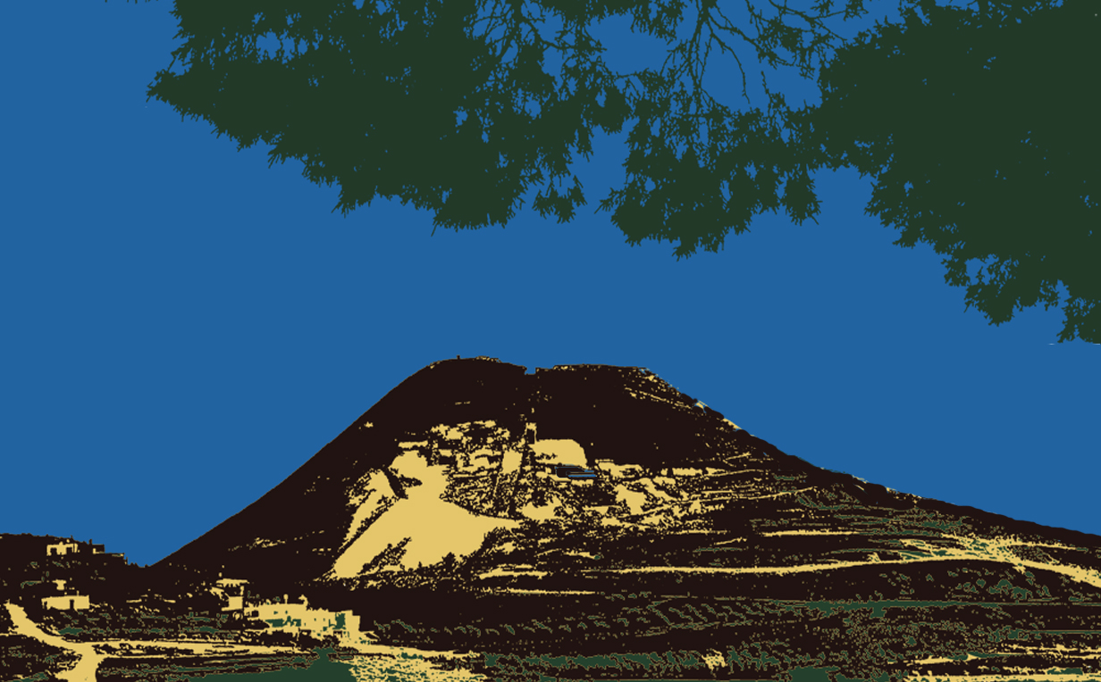
This so infuriated the congregation that they wanted to throw him off a nearby cliff. Just outside Nazareth, Mount Precipice is believed to be the site described in Luke 4:29-30 but “he passed through the midst of them and went away.”

St Joseph church

St Joseph’s Church marks the traditional place of Joseph’s carpentry workshop.

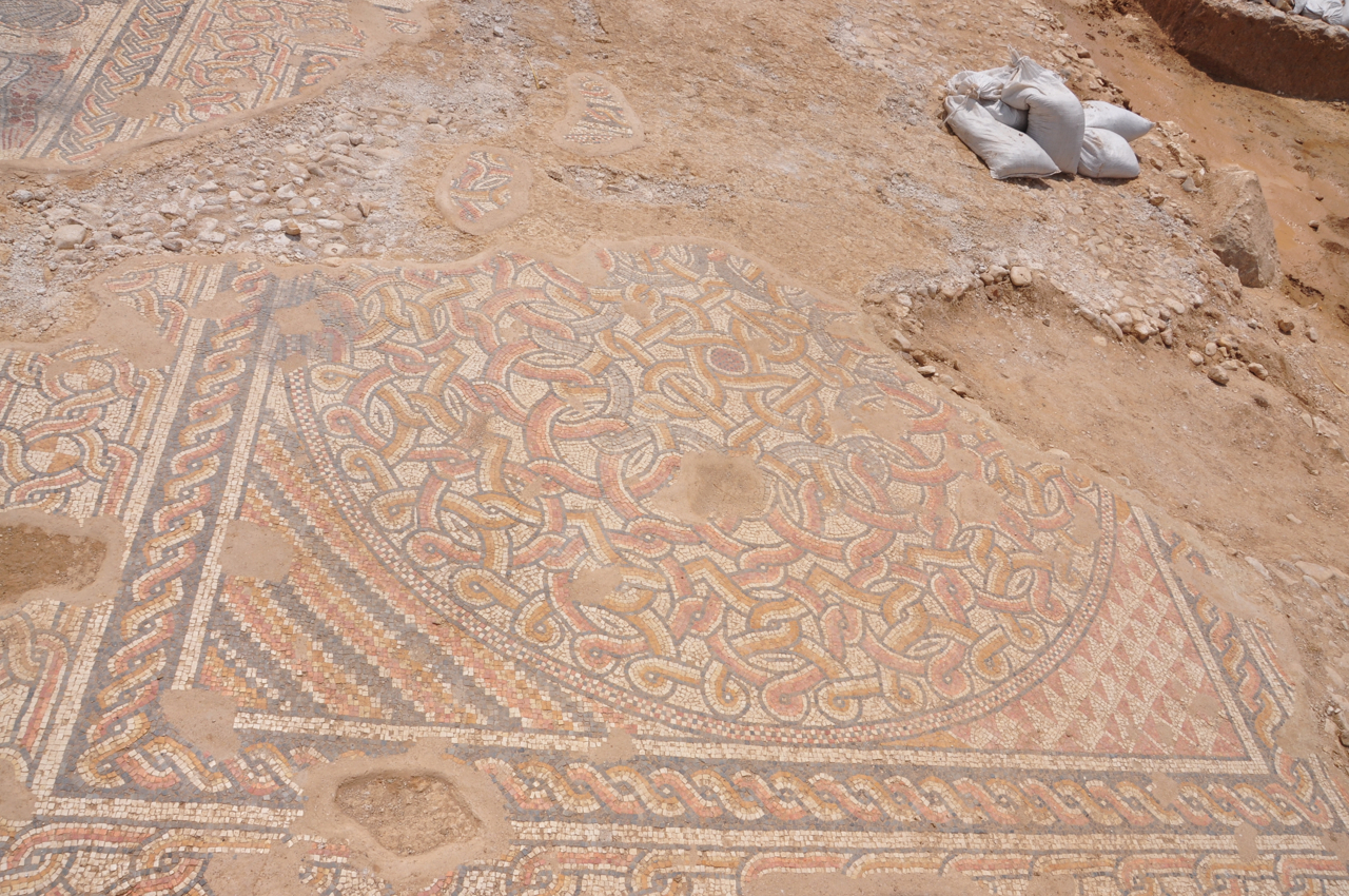
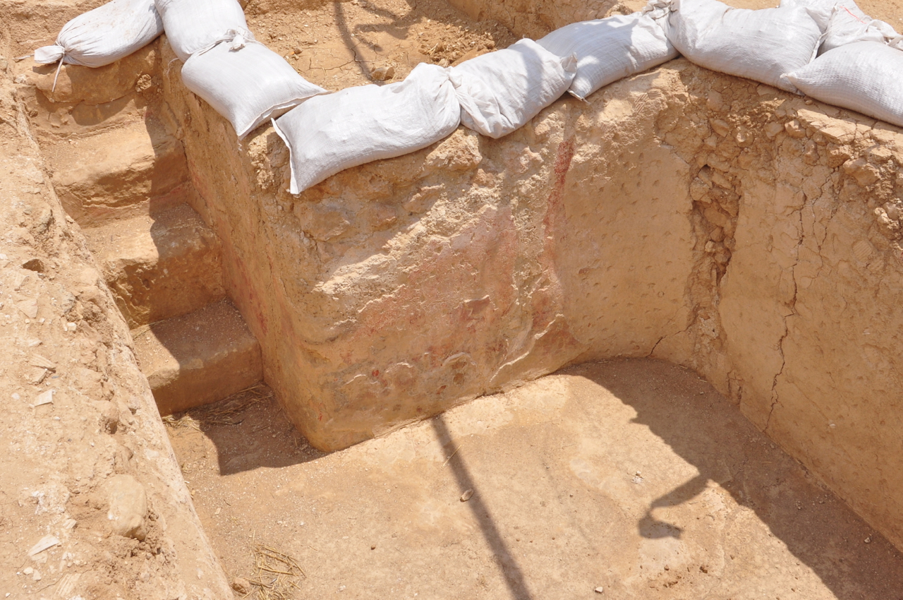
Under the Mary of Nazareth International Center, next to the Church of the Annunciation, an archaeological excavation recently conducted by the Israel Antiquities Authority has uncovered remains of a dwelling that date to the Early Roman period. According to excavation director Yardenna Alexandre, “The discovery is of the utmost importance since it reveals for the very first time a house from the Jewish village of Nazareth and thereby sheds light on the way of life at the time of Jesus”.

Based on solid New Testament scholarship and the most up-to-date archaeology, Nazareth Village brings to life a farm and Galilean village, recreating Nazareth as it was 2,000 years ago, when Jesus lived there.

Church of Annunciation, Muzio

Church of the Annunciation is the largest Catholic church in the Middle East. In Roman Catholic tradition, it marks the site where the Archangel Gabriel announced the future birth of Jesus to the Virgin Mary (Luke 1:26-31). The new modern, fortress-like basilica was designed by the Italian architect Giovanni Muzio and built by the Israeli construction firm Solel Boneh during the years 1960-69.

Mosaics at Bet Qama

Israel Antiquities Authority reported on excavations it is carrying out prior to construction of the extension of highway 6 north of Beersheva.

Byzantine crossRemains of a settlement that extends across more than six dunams were uncovered in the excavation being conducted in the fields of Kibbutz Bet Qama. The site seems to have consisted of a large estate that included a tower, a church, residential buildings, presumably an inn for travelers, and storerooms, a large cistern, a public building and pools surrounded by farmland. Also found was a stone with a Byzantine cross in secondary usage. It seems to me that this would be a good candidate for a monastery. Bet Qama excavationThe public building was a large hall 12 meters long by 8.5 meters wide. A spectacular colorful mosaic dating to the Byzantine period (4th–6th centuries CE) was exposed in recent weeks. The well-preserved mosaic consists of 3 square sections each surrounding a circle decorated with geometric patterns. One has amphorae (jars used to transport wine) in two opposite corners, one with a pair of peacocks, the other a pair of doves pecking at grapes on a tendril. These are common designs that are known from this period; however, what makes this mosaic unique is the large number of motifs that were incorporated in one carpet.

North carpet

Middle carpet

South carpet

Pools and a system of channels and pipes between them used to convey water were discovered in front of the building. Steps were exposed in one of the pools (not a ritual bath, miqve, according to IAA) whose walls were covered with multiple layers of colored plaster (fresco) implying that whatever the pool was later used for, it continued for some time – no theory about what it might have been used for.

Pool w frescoArchaeologists in the Antiquities Authority are still trying to determine the purpose of the impressive public building and the pools whose construction required considerable economic resources. No destruction layer was found, the site was vacated in the Early Arab period.

In other excavations nearby, two Jewish settlements were found. At Horbat Rimon a synagogue and miqve were exposed. At Nahal Shoval the remains of two Jewish ritual baths and two public buildings were uncovered. Both of the public buildings feature raised platforms along the walls facing Jerusalem, a feature of Jewish synagogues of the period.

Bethesda Pool and Church of Santa Anna

Near Lion’s Gate is a large wooden door that gives access to the White Fathers’ compound and one of my favorite sites in Jerusalem’s Old City – Bethesda pools and the Church of Santa Anna.

Mary (mother of Jesus) was born to Anna and Joachim who lived near the Bethesda pools.  Because Jerusalem is on the edge of the Judean desert water has always been crucial for the residents of the city and the first pool was built in the 8th century BCE, when a dam was built across the valley, collecting rain runoff in a reservoir (40×50 meters), known as the Upper Pool. A sluice-gate in the dam allowed the water height to be controlled, and a rock-cut channel brought the water into the city. Around 200 BCE, the channel was enclosed, and a second pool (50×60 meters) was added on the south side of the dam.

Bethesda pool

In the 1st century BC, natural caves to the east of the two pools were turned into small baths, as part of an asclepieion, a healing temple. As it was outside the city walls, scholars think it likely that the Roman garrison of the nearby Antonia Fortress built the site as they would have been able to protect it. According to Christian tradition the site is one of two places in Jerusalem where Jesus performed a miracle, healing a paralytic of 38 years (John 5:1-15).

In the mid 1st century CE, Herod Agrippa built the third wall enclosing the northern area of the city and bringing the asclepieion within the walled city. When Hadrian rebuilt Jerusalem as Aelia Capitolina, he placed a roadway along the dam, and expanded the asclepieion into a large temple to Asclepius and Serapis. In the Byzantine period, 5th century, a large church was built on the dike, requiring support of two rows of arches.

After the Crusader conquest of Jerusalem in 1099, the Byzantine church, destroyed by the Persians in 614 CE, rebuilt by patriarch Modestus and destroyed in 1009 by the Fatimid Caliph Al-Hakim, was rebuilt on a smaller scale. A new Romanesque church, named for Saint Anne was completed in 1138 CE by Arda, widow of Baldwin I, the first Crusader King of Jerusalem, built over the site of a grotto believed by the Crusaders to be the birthplace of Mary. After the conquest of Jerusalem by Saladin it was transformed into a school for Islamic jurisprudence. Over time, the buildings fell into ruin. In 1856, the Ottomans, in gratitude for French support during the Crimean War gave the site to France. It was subsequently restored, but the majority of what we see today is original.

Santa Anna interiorThe three-aisled basilica incorporates cross-vaulted ceilings and columns, clean lines and an unadorned interior. Because of the fine stonework and large volume of the church the acoustics are amazing. The altar is by the French sculptor Philippe Kaeppelin – on the front of the altar are depicted the Nativity, the Descent from the Cross and the Annunciation; on the ends the teaching of Mary by her mother and her presentation in the Temple.

Kaeppelin altar

Photo of the Week – Dor Habonim beaches

This photo is at sunset at one of my favorite Israeli, Mediterranean coast beaches. Just south of Haifa called Hof Habonim, it is part of a coastal nature reserve under the Israel Parks Authority. There are two natural lagoons protected by natural rock jetties, picturesque and calm.

HaBonim IMG_0204

The technical details – the photo was taken with a Canon point and shoot camera in October (ISO 50, 12.5mm, F3.5 at 1/160 sec).

If you tire of hanging out at the beach there is a lovely walk along the coast south to the beach at Dor-Nachsholim. There you can rent sea kayaks, check out the excavations at the tel and visit the Mizgaga museum. The museum, housed in the 1891 factory that attempted to manufacture wine bottles for Baron de Rothschild’s wines, displays regional and nautical archaeological finds.

You can click on the image for a larger view (which may take some time to load depending on your Internet connection). Please share this post with your friends by clicking on the icons at the end of this message.

Photographs on this website are © Shmuel Browns (unless marked otherwise) – if you are interested in purchasing one of my photos or using one of my photos for your own project please contact me.

Nebi Samuel

Nebi Samuel Overlooking the ancient route from Beit Horon to Jerusalem (today highway <436>) is a tree-covered, limestone mountain (885 meters high) that gets its name from the Hebrew prophet Samuel who according to Judaism, Christianity and Islam is buried there. Another tradition, supported by archaeological evidence, is that this site is Mizpeh, where Samuel anointed Saul, the first King of Israel and where King Solomon made a thousand burnt offerings at the high-place of Gibeon – the biblical city of Gibeon is only 1.5 km north of the site, today the Palestinian village of el-Jib, behind the separation wall. Excavations, still ongoing, have uncovered the remains of settlements from both the First Temple (7th century BCE) and Second Temple (Hasmonean) periods.

Nebi Samuel, Second Temple

According to the Biblical text I Samuel 25:1 it says that “Samuel died and all Israel gathered and lamented him and buried him in his home(town) in Ramah”. If this site is Mizpeh, then there would be a problem. In the Byzantine period (6th century), Christian tradition said that the prophet’s bones were relocated here and a monastery was built at the site to honor Samuel. In 1099, during the First Crusade, the Crusaders saw Jerusalem for the first time from here and named the mountain, Mons Gaudi (Mountain of Joy). There is still a great view of Jerusalem but of course a much different view than what the Crusaders saw. As part of the fortress that they built there in the 12th century, was a Romanesque style church over the burial cave and a hostel for Christian pilgrims on their way to Jerusalem. When the Crusaders were defeated by the Arabs under Salah a-Din in 1187 the fortifications were destroyed. In the 14th century the Mamelukes converted the church to a mosque. The building and minaret we see today is neither Mameluke nor Ottoman (though the lovely inscription over the door is) but rebuilt by the British after WWI – in the heavy fighting between the Turks and British and aerial bombardment by the British for the strategic hill damaged the building. Jewish armies fought here, from forces led by Judah the Maccabi against the Seleucid-Greeks in 165 BCE to the Harel Brigade who failed to capture the mountain during the War of Independence (1948) but were successful in the Six-Day War (1967).

Preparation of moat

On the western side you can see a section of the moat that was never completed, the large blocks of limestone stand detached ready to be quarried. The path continues past a small Muslim cemetery through an orchard of old olive and fig trees to a spring, named for Hannah, Samuel’s mother, that flows out of a cave in the bedrock.

Hannah's Spring

Israel Roundup

ARTIFAX magazine and The Book & The Spade radio program have published the Top Ten Discoveries in Biblical Archaeology in 2012. At #3 is a First Temple period cistern with a 250 cubic meter capacity that was discovered by chance during the ongoing clearing of the drainage channel near Robinson’s arch. Press release at http://www.antiquities.org.il/article_Item_eng.asp?sec_id=25&subj_id=240&id=1958&module_id=#as

Photo credit: Courtesy of the Israel Antiquities Authority/Vladimir Naykhin

Photo credit: Courtesy of the Israel Antiquities Authority/Vladimir Naykhin

Found while sifting material from City of David, at #4 is a fiscal bulla, a clay seal impression with three lines of script, related to the taxing of shipments at the time of King Hezekiah, the earliest mention of Bethelehem. Found while sifting material from drainage channel near Robinson’s arch, at #5 a personal seal with the name Matanyahu inscribed on it dated to the end of the First Temple period, see https://israeltours.wordpress.com/2012/05/03/first-temple-period-seal/

Jewish National Fund (JNF) has published a map of Israel with 110 “great old” trees marked. One example, #91, a Common Oak, called the “Lone Tree” symbolizing the Gush Etzion bloc south of Jerusalem that has a height of 10 meters, trunk circumference of 3.5 meters and is estimated to be 500 years old. I do a tour that includes the moving audio-visual presentation on the history of the Gush at Kibbutz Kfar Etzion, gourmet lunch at Gavna in the forest with a view all the way to the Mediterranean and a tour of the Lone Tree microbrewery.

Lone Oak

Herod the Great: The King’s Final Journey exhibit at the Israel Museum is an exceptional opportunity to encounter the material opus of Herod the Great – his architecture and aesthetics, and the work of his chief archaeologist, Professor Ehud Netzer. Evidence of Herod, the meaning, struggles, and accomplishments of his life beckon beyond the exhibit halls, to the sites where he fought, ruled, dreamed, and built – Herodium, Masada, CyprosSebasteCaesarea, Banias and Omrit

Herodium-4colourFor those who will be in Israel, I am leading in-depth full-day tours of Herodium and the Israel Museum’s Herod exhibit, for details see https://israeltours.wordpress.com/herod-the-great-tour

For those who will not be able to visit Israel, I posted a few articles with photos of the exhibit.
Here are the links to check for photos:

The Israel museum has published a 277 page hardcover catalog of the exhibit. You can order a copy by sending an email to shop at imj.org.il
ARIEL has released volume 201-200 Art and Architecture in Jerusalem and Israel in the Second Temple Period (in Hebrew) in memory of Prof. Ehud Netzer.

From the pantry at Herod’s palace-fortress at Masada, amphorae – large clay jars that held imported delicacies – attest to the luxury and sophistication of Herod’s palate: apples, honey, fine wine, and garum, a savory Roman fish sauce. One amphora bears an inscription of Herod’s name in Latin and Greek. For more about garum, https://israeltours.wordpress.com/2010/11/25/food-discoveries-masada-garum/

Film documentary: Volunteers with military experience, many from America, came to Israel around 1947 to help the fledgling Jewish state. Their acronym, Mahal (MH”L}, stands for מתנדבי חוץ לארץ. The 3 large Hebrew letters, מח’’לֹ, stand as a monument at Sha’ar Hagai, on the road to Jerusalem. Playmount Productions has released a sample from their upcoming documentary Above and Beyond: The Birth of the Israeli Air Force.

Emek Habacha project: Estimated at €250 million to install 50 130 meter tall (height of the Azrielli Towers in Tel Aviv) wind turbines able to produce 120 megawatts has received approval. These will replace the 10 wind turbines that produce 6 megawatts at Tel Asania. I blogged about the old wind turbines in May 2011 at https://israeltours.wordpress.com/2011/05/02/wind-turbines-on-golan-trail/