Lights over Egypt, Israel and Jordan from Space

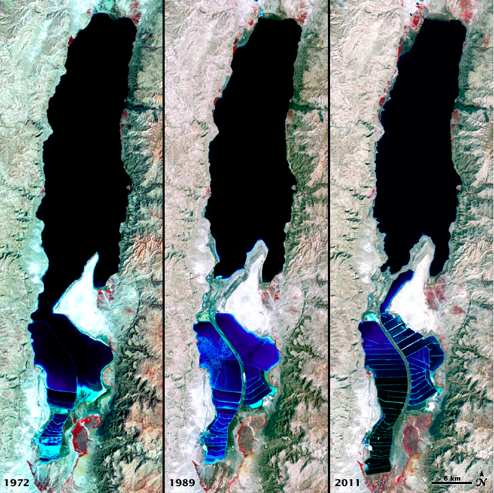
Nasa’s EarthObservatory site is a great website about our Earth. After posting the photos about the changes in the Dead Sea I remembered another image of this region, the Nile delta in Egypt and neighboring Israel and Jordan taken at night from Space. You can see clearly based on the lit up areas where the major populations are situated. Israel is pretty brightly lit up suggesting that a) we use a lot of electricity for lights and/or b) the northern part of our small country is relatively densely populated.

From the EarthObservatory website:

The Nile River and its delta look like a brilliant, long-stemmed flower in this astronaut photograph of the southeastern Mediterranean Sea, as seen from the International Space Station. The Cairo metropolitan area forms a particularly bright base of the flower. The smaller cities and towns within the Nile Delta tend to be hard to see amidst the dense agricultural vegetation during the day. However, these settled areas and the connecting roads between them become clearly visible at night. Likewise, urbanized regions and infrastructure along the Nile River becomes apparent.

Another brightly lit region is visible along the eastern coastline of the Mediterranean—the Tel-Aviv metropolitan area in Israel (image right). To the east of Tel-Aviv lies Amman, Jordan. The two major water bodies that define the western and eastern coastlines of the Sinai Peninsula—the Gulf of Suez and the Gulf of Aqaba—are outlined by lights along their coastlines (image lower right).

Scattered blue-grey clouds cover the Mediterranean Sea and the Sinai, while much of northeastern Africa is cloud-free. A thin yellow-brown band tracing the Earth’s curvature at image top is airglow, a faint band of light emission that results from the interaction of atmospheric atoms and molecules with solar radiation at approximately 100 kilometers (60 miles) altitude.

Astronaut photograph ISS025-E-9858 was acquired on October 28, 2010, with a Nikon D3S digital camera using a 16 mm lens, and is provided by the ISS Crew Earth Observations experiment and Image Science & Analysis Laboratory, Johnson Space Center. The image was taken by the Expedition 25 crew.

Dead Sea Shrinking

Dead Sea Shrinking (1972, 1989, 2011)

The Dead Sea is less than an hour drive from Jerusalem so it’s an area that I guide often. I always point out the two black lines on the rocks to the right of the highway across from Ein Feshka, the levels of the sea as recorded by the Palestine Exploration Fund in the 1920s and explain that the Dead Sea is shrinking by a meter a year. I usually get asked how the Dead Sea has changed over time. These satellite photographs from Nasa’s Earth Observatory website show it clearly.

The false-color images above were captured by the Landsat 1, 4, and 7 satellites on September 15, 1972, August 27, 1989 and October 11, 2011.
All three images include a combination of near-infrared, red, and green wavelengths. Deep waters are blue or dark blue, while brighter blues indicate shallow waters or salt ponds (in the south). The pale pink and sand-colored regions are barren desert landscapes, while green indicates sparsely vegetated lands. Denser vegetation appears bright red. Near the center is the Lisan Peninsula, which forms a land bridge through the Dead Sea.

For more information about the Dead Sea check out my blog post here.

Almond Blossoms on Tu Bishvat

The 15th of the Hebrew month of Shvat is the holiday of Tu Bishvat which according to the sage Hillel is the New Year of Trees, the date from which the age of a tree is calculated for the purpose of biblical tithes.

Almond Blossom Jerusalem

Associated with the holiday is a festive meal of at least 10 different fruit including the 7 species (grape, fig, pomegranate, olive, date and 2 grains, wheat and barley) that are mentioned in the Bible as growing natively in the land of Israel. We drink 4 cups of wine in varying hue (white, pink and red), corresponding to the 4 seasons and the 4 aspects of creation according to the Kabbalah. This formula corresponds to the tradition inaugurated in the 16th century in Tzfat by the Ari, Rabbi Yitzchak Luria and his disciples of a Tu Bishvat seder in which the appropriate blessings on the fruit and wine would bring the world closer to spiritual perfection.

Another tree that is strongly connected to Tu Bishvat is the almond (Prunus dulcis) native to the Middle East and South Asia. The almond tree is the first tree to blossom after the winter rains in Israel and so is the precursor of spring. There is even a song for the holiday about the almond tree.

The almond tree is blossoming,

 A golden sun is glowing

Birds sing out in joyous glee 

From every roof and every tree.

השקדיה פורחת 

ושמש פז זורחת

צפורים מראש כל גג

.מבשרות את בוא החג

Near Jerusalem, there are almond trees in Emeq HaMatzleva, the Sherover promenade, Sataf, Ein Kerem, Nahal Katlav, Bab el Wad. So today I went out to appreciate the almond trees, newly awakened and covered with delicate white and pink flowers in the Valley of the Cross.

If you have tasted the fruit of the wild almond it is very bitter. This is because it contains the glycoside amygdalin which becomes transformed into a deadly poison, prussic acid (hydrogen cyanide) after crushing, chewing, or any other injury to the seed.

Besides the almonds there were cyclamen and red anemones (kalaniot כלניות); there were also 3 researchers banding and recording birds (the Jerusalem Bird Observatory is nearby).

Hiking Nahal Mikhmas

On Monday we drove out of Jerusalem on highway 437 past Pisgat Zeev to get to the starting point of our hike in the northern Judean desert. On the way, about 5km north of Jerusalem on the left along the watershed ridge at 839m above sea level is Gibeah (of Saul) or Givat Shaul usually pointed out as the location, Tel el-Ful, where King Hussein of Jordan began construction of his Royal Palace in the 1960s.

The site has a number of important Biblical/historical references:

• The Concubine of Gibeah, and the ensuing Battle of Gibeah between the Israelite tribes against Benjamin (Judges 19-21)

• Israel’s first king, Saul, reigned from Gibeah for 38 years (1 Samuel 8-31)

• Prophetic mention during the period of the Divided Kingdom (Hosea 5:8, 9:9, 10:9; Isaiah 10:29)

• The encampment of the 10th Roman Legion in their assault on Jerusalem in 70CE (Josephus, War of the Jews)

Just before we arrived at our destination on the right we passed another site, Qubur Bani Israel (Tombs of Children of Israel), 4 large narrow rectangular walled structures measuring 15 by 3 meters which rise from a rocky plateau overlooking Wadi Qelt. The megaliths still have two or three rows of gigantic, rough-hewn stones carefully in place. The name refers to the site being an ancient Jewish burial ground in the territory of Benjamin; archaeologists estimate the date as 2000BCE. A theory proposed by Noga Reuveni (who also established the biblical gardens of Neot Kedumim) is that in fact this site marks the tomb of Rachel who was buried “on the road to Efrat, now Bet Lehem (Bereishit 35:19)”. There is a city Farah settled near the spring Ein Farah that is mentioned among the cities of Binyamin (Joshua 18:23) and it is not unreasonable to posit that it was alternatively called Efrat (same Hebrew root). Since the city was in an area of wheat and barley, it was later renamed (like other cities) Bet Lehem. This also matches the description to Saul before his return home to Gibeah.

When you leave me today, you will meet two men near the tomb of Rachel in the territory of Benjamin (1 Sam. 10:2)

This should have been a clue that this was not going to be just a nature hike.

We started hiking from Geva Binyamin, also called Adam. Because the area is in Judea and Shomron/the West Bank we had to arrange clearance with the army and get the security officer to open the gate from the settlement. Geva Binyamin was founded in 1984 and in 2007 had a population of 3500 people. It sits between the Arab towns of Jabah and Mikhmus that recall the towns of Geva and Mikhmas mentioned in the Bible.

Open a TaNaKh and read 1 Samuel, chapters 13 and 14 for the account of the battle between King Saul and his son Jonathan against the Philistines. The Israelite forces are camped at Geva and the Philistines are on Mikhmas with the wadi separating them. Jonathan sneaks out of the camp at night and hidden by the deep walls of the canyon makes his way to the Philistine garrison… We were standing on the ridge reading the account of the battle, overlooking the area where it took place.

The black trail follows the ridge above Nahal Mikhmas. Hidden among a pile of rocks is the spring of Ein Suweinit. Many caves can be seen and we stopped at two of them, El-Jai is one of the largest in the Shomron.

From there we descended the steep cliff to the nahal, actually quite challenging because of the slippery rocks and mud.

Because of the rains we saw two flowers, the tiny purple Grape Hyacinth, in Hebrew, Kadan and bunches of white Desert Bulbs, Bezalziya.

Dark Grape Hyacinth (Muscari commutatum), also bulb, cluster of tiny flowers like jugs that hang upside down to protect the pollen from rain.

A rosette of grey-green leaves emerges before the flowers, 6 petals with a stamen on each, blooms for 5-6 weeks which is long for bulbs, grows among rocks to protect the bulbs from being dug up by porcupines and other animals.

Where Nahal Mikhmas joins Wadi Qelt the trail changes to red and we followed it to the left/east to Ein Mabu’a/Ein Fawwar. This spring is an artesian or karstic fountain, which flows from a cave into a round concrete pool built by the British in the 1920s. Until the Six Day War, the water was pumped to East Jerusalem, but today it is no longer used. In the Second Temple period an aqueduct brought water to the fortress at Cypros and there is a mosaic floor from a Byzantine church. If mosaics interest you then visit the nearby museum at Inn of the Good Samaritan.

Responsible Travel

In line with the United Nation World Tourism Organization’s Global Ethics for Responsible Tourism, I am committed to responsible tourism that benefits local communities and is respectful of the nature, religions and culture of the place.

Shmuel Browns, Licensed Israel tour guide #8203         

When you hire me as your guide you will be working with someone committed to the land, environment and people, to tikkun olam, the healing of our world. Here are some suggestions about what you/we can do.

When hiking take a plastic bag so that you can carry out your garbage. If you come across plastic bottles, bags, tins that others left behind add them to your garbage. Leave every place cleaner than you found it.

Take a spork (spoon/fork) and knife, a bowl and cup with you so you won’t have to use and then throw out disposable plastic.

Israel is hot so it is important to drink to prevent dehydration. It’s not necessary to buy bottled water (save the plastic bottle), the water in Israel is fine to drink.

Handling all the plastic (bottles, bags, packaging) puts a strain on Israel’s resources. Israel has a bottle law, you pay a deposit on wine and beer bottles, aluminum cans and small plastic bottles – these should be returned to a supermarket that will give you your deposit back and recycle the material; alternatively, leave these where people can collect them and get the money for returning them. Israel recycles large plastic bottles, paper and cardboard so make the effort to recycle these items in the appropriate wire cages and containers on the street.

Conserve water! With climate change Israel has had less rain and the Sea of Galillee, the main fresh water reservoir is low, below the red line. Shut the water while taking a shower and while brushing your teeth, use the half-flush on the toilet.

Plant a tree in Israel by contacting the JNF/KKL (to help offset your carbon footprint and fulfill the Biblical commandment from Lev 19:23, When you come to the land and shall have planted all manner of trees for food…). Since its inception in 1901, the JNF has planted over 240 million trees, built 180 dams and reservoirs, developed 250,000 acres of land and established more than 1,000 parks.

To plant a tree with your own hands in the soil of Israel contact the JNF/KKL to make arrangements for your family or group (give them at least a weeks notice) at (02) 658-3449 or via email michalh at symbol kkl.org.il  If you have less than 7 people you can call the appropriate forester directly. For planting in the Jerusalem area (Aminadav forest), contact Aviram at 054 622-6213 and for planting in the north (Lavie forest), contact Yossi at 050 546-9069. You can also check the JNF/KKL website.

To plant an olive tree at Neot Kedumim, the Biblical Landscape Reserve, go to their website.

Travel by public transportation, rent a bike and walk when convenient.

Eat at restaurants that have a Tav Hevrati, “a seal of excellence that certifies business for upholding fair labor laws and implementing handicap accessibility measures. It rewards businesses that act ethically towards their workers, thereby promoting righteousness and justice in accordance with the values of justice and ethics in the Jewish tradition.”.

Hire a knowledgeable, local guide licensed by the Israel Ministry of Tourism.

Choose to take a walking tour.

Visit local conservation or social projects on your trip and find out how you could help support them.

Make an effort to learn a few words or phrases in the languages spoken – here are some basics:

Hello Shalom Saalam
Please Bvakasha
Thank you Toda Shukran
Sorry Slicha Afwan
Good morning/Good evening Boker tov/Erev tov Sabah el kheer/Masaa el kheer
How are you? Ma shlomkha? Kif halek?

You can check out this website for Hebrew and Arabic words and phrases that could come in handy.

http://www.linguanaut.com/english_hebrew.htm
http://www.linguanaut.com/english_arabic.htm

Please visit the ResponsibleTravel website for more suggestions on how to be a responsible traveler.

Cable over Hinnom valley

Walking along Derekh Hevron towards the Old City you pass the Mount Zion Hotel on your right. Without a guide it is doubtful that you will notice the coat of arms sculpted in the stone of the building or recognize its significance. This is the emblem of the Order of St. John, a British charitable organization dating back to the time of the Crusades. They arrived in the Holy Land in 1882 and purchased land opposite Mount Zion overlooking the Hinnom valley with the aim of establishing an eye hospital. The hospital served Muslims, Jews, and Christians from all over the Middle East until WWI.

During the war the Ottomans took over the building for use as an arms warehouse and parts of the hospital were destroyed by British shelling. An earthquake with epicenter near Jericho on July 11, 1927 damaged buildings in Jerusalem, including the hospital. British architect Clifford Holiday was in charge of the renovations of the hospital in the 1930s adding two new wings, the second on the other side of the road (today the Jerusalem House of Quality, a gallery and artists’ workshops, worth a visit). Holiday also built  the nearby Scottish Church on Ketef Hinnom and the original Jerusalem City Hall.

Without a guide it is doubtful that you would notice a box hanging on a cable from the corner of one of the buildings or understand its significance. During the Israel War of Independence the terrain and Jordanian sniper fire made it difficult to move men and supplies between the western part of the city and Mount Zion, both in Israeli hands. A tunnel was dug crossing the wadi but this only provided limited access. So in December 1948 Uriel Hefetz, an engineering corps commander at the Etzioni Brigade, conceived of the idea of stretching a 200-meter steel cable across the Hinnom Valley from a room in the hospital to the Israeli post at the Eretz Hatzvi school on Mount Zion. It was used during the night to transfer medicine and arms to Mount Zion and the wounded to the hospital. During the day the cable was lowered to the ground so it would not be discovered by the Jordanians. The cable was inclined with a maximum height of about 50 meters above the wadi. The cart that ran on the cable was just large enough for one person but could carry a weight of about 250 kilos. The original room has been made into a small museum housing the winch mechanism and other period artifacts.

PetitYou won’t find this anecdote in any of the guide books, another advantage to hiring a guide. In 1987, Teddy Kollek, the mayor of Jerusalem invited the French high-wire performer, Philippe Petit (earlier, on August 7, 1974 Petit had walked between the Twin Towers of the World Trade Center in New York City), to walk the inclined cable across the Hinnom valley as part of that year’s Israel Festival. The performance,  A Bridge for Peace, drew a crowd of 50,000 people from all parts of the city who stood in amazement. An Israeli, Uri Dromi wrote an Op-Ed piece in the December 16, 2009 edition of the New York Times where he reminisces about watching Petit.

This was just few months before the first Intifada, but the excited crowd that gathered there on a sunny day had no clue of the lava ready to erupt below. Their eyes were glued onto the brave Frenchman and they held their breath for an agonizingly long time until he finally touched the safe ground on the other side.

From the hotel you look across the Hinnom valley at Mount Zion, the Arab-Jewish neighborhood of Abu Tor and the Arab villages on the surrounding hills.

“This was a very important memory for me,” said Petit. “That’s what the wire can do, when you link two mountains, you link the people who live on those mountains.”