Tag Archives: hike

Masada at Sunrise

Masada is one of the most visited historical/archaeological sites in Israel, an isolated rock cliff in the Judean desert overlooking the Dead Sea.

Masada cable car
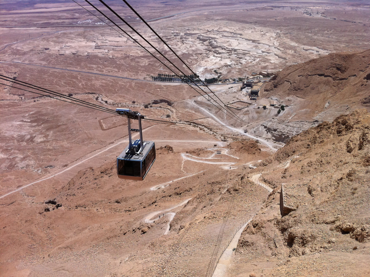
Although there is a cable car that will take you to the top of the mountain, a tradition has grown up to climb the Snake Path, a zig-zag trail, early in the morning in order to reach the summit in time to watch the sunrise – that’s what we did. The top is only 59 meters above sea level but remember that you’re starting at about 400 meters below sea level. You should be able to climb it in 45 minutes to 1 hour. If you want to do this the best place to stay the night before is the youth hostel at the base of Masada.

I recently read an article on the Israelity website about a group of 7 seniors from the Cedar Village retirement community near Cincinnati who came to Israel to celebrate their bar/bat mitzvahs and tour Israel including climbing Masada – their average age was 85 years old, the oldest was 97!

I guided two families traveling together, a group of four adults and five children, during their time in Israel. When we reached Masada and saw the mountain some were interested in climbing the Snake path. We didn’t really have enough time so one of the Dads suggested running it. At first no one took him seriously, so Chris said he’d do it. I showed him where the path started and he was off. The rest of us took the cable car and on our way up looked for Chris. I finally saw him on the last turn of the path before the summit – his time 17 minutes! For Bernie’s description of their experience check out their blog at http://keepingupwiththemounts.blogspot.co.il/2011/11/masada.html

Masada (from Arad)

Another option is a nice hike that starts at the same but splits from the Snake Path, you walk north on the red trail following the circumvallation wall built by the Romans around the mountain. You pass the 4th siege camp (northernmost) and follow the trail west and then south. As you climb there’s a great view of the Northern Palace hanging on the cliff and the water cisterns on the western side. You can go to see the cisterns and/or climb the Roman ramp to the summit.

Hiking Nahal Yehudia

Day 2: Hiking Nahal Yehudia
After a breakfast of fruit and homemade granola we drove to Nahal Yehudia off highway <87>. The hike is listed as appropriate for good hikers who can swim as there are a couple of places where you have to climb down the rock face with the help of handholds or a ladder into a deep pool that you have to swim across. The trail is one of eleven listed in the Park’s brochure on the Yehudia Forest Reserve, including Nahal Zavitan, the Meshushim (hexagonal basalt pillars) pool and Gamla which includes the archaeological remains of the Jewish town that fought against Vespasian at the start of the Jewish Revolt in 66CE and Griffon vultures that can be seen flying overhead. There is parking, bathrooms, drinking water, a snack bar and information center (the park warden we spoke to was very helpful); the entrance fee was 20 NIS per person. Note that you must start out on the trail by noon.

DSC_0161

The hike starts above the wadi, walking through a deserted Syrian village built on the remains of an earlier Jewish one of basalt field stones from the Roman-Byzantine period. Remains of a wall have led archaeologists to suggest that Yehudia is Soganey, one of the three fortresses (the other two are Gamla and Sele’ukya) in the Golan built by Josephus at the time of the Roman Revolt. You walk on a path strewn with basalt, by pasture land where you may see cattle grazing.

DSC_0171

Then you walk down into the wadi to the Yehudia Falls and the first pool, good for a cool dip especially if it’s a hot day.

DSC_0177

At this point we changed out of our hiking boots and into water sandals as there are places where you walk in the water. Continuing along the wadi you get to the first descent. U-shaped handholds have been attached to the rock to help you get down about 4 meters. This is just your warm up. The trail brings you to a cliff where you descend 9 meters by metal ladder into a pool. There is no place to stand, you step off the bottom rung of the ladder and swim across to the other side of the pool.

DSC_0184

The challenge is what to do to keep your gear dry (and in this day and age with cell phones, cameras, car keys with electronic locks, etc. we have stuff that won’t work if it gets wet). We used the double garbage bag technique but also saw a group float their packs across on a small inflatable boat, you can rig up a rope and omega your pack across or probably safest, pack in professional waterproof bags used for kayaking.

After traversing the pool you come to another descent, this time about 4 meters with only handholds. At the bottom you have the option of swimming or walking across the pool as it isn’t that deep. Be careful as it is slippery walking on the rocks. The water can be quite cold so it’s great that there is a place in the sun to sit on some large rocks and have a snack.

DSC_0182

Using the 2 large plastic bags that we had brought for our packs, we picked up a bunch of garbage that we carried out with us. We continued along the wadi, sometimes walking on the rocks, sometimes in the water. At the well marked junction you can leave the red trail to take the green back to the Syrian village or continue  along the wadi a bit further to one last pool and waterfall. Then we backtracked and took the green trail up out of the wadi, back to the Syrian village and the trail head. It was just the middle of November but there were already cyclamen and narcissus in bloom.

You can view a fuller set of photographs from this Golan trip on Flickr at http://www.flickr.com/photos/27944012@N06/sets/72157622790431204/

Hike Sea to Sea

Israel packs a lot into a small country, mountains, desert, coast, forests (over the past 100 years, the Jewish National Fund has planted over 240 million trees and in fact, Israel is the only country that entered the 21st century with a net gain in its number of trees). There are 4 seas, the Mediterranean, Red, Dead and the Sea of Galilee (at 209 m below sea level, the lowest fresh-water lake in the world), in Hebrew, the Kinneret.

Because Israel is small, it’s possible to hike the width of the country in a few days, from sea to sea, yam l’yam, from the Mediterranean to the Sea of Galilee.

Mediterranean Sea

Coastline of Mediterranean Sea

Kineret Sea of Galilee

Overlooking the Kinneret, Sea of Galilee

There are even rituals to perform, you start and end by immersing all or part of your body in each sea and you carry some water with you from one sea which you pour into the other sea when you arrive.

The hike starts at Achziv, follows Nahal Kziv past the Crusader Montfort Castle, Ein Tamir and on to the Druze village of Horpish. From there we join the Israel Trail, past Har Meron to Nahal Amud. We climb to Mizpe Yamim with a view of the Mediterrranean Sea from whence we came and below us the Sea of Galilee where we will end our hike. This hike takes 3 to 4 days, accommodation can be arranged at Bed & Breakfasts along the route.

You can also hike or drive between the other seas: 2) from the Red Sea at Eilat, along the southern part of the 940 km. Israel Trail to the area of the Dead Sea, 3) from the Mediterranean to the Dead Sea, 4) follow the Great Rift valley and drive between the Dead Sea and the Kinneret. Before you do, you might want to read Haim Watzman’s personal account in his recent book, A Crack in the Earth: A Journey up Israel’s Rift Valley:

“This rift is one of the globe’s largest features, clearly visible from space, and I live on its edge. It forms an intricate landscape that makes the human soul turn end over end in wonder…”

Hike above Bab el Wad

We’ve just passed Tu B’Shvat, the New Year of the Trees – the almond trees are blossoming in the hills of Jerusalem. There’s a special hike in the Masger reserve, overlooking the road to Jerusalem above Bab el Wad, the gorge that marks the entrance to the hills that leads to the city. We should remember that in 1948, the convoys of trucks carrying food for the inhabitants of Jerusalem were attacked along this road and Israelis lost their lives. Just like in the Haim Gouri poem, Bab el Wad, the cyclamen and anemones were blooming.

יום אביב יבוא ורקפות תפרחנה,
אודם כלנית בהר ובמורד.

באב אל וואד
לנצח זכור נא את שמותינו,
באב אל וואד בדרך אל העיר.

A spring day will come, the cyclamens will bloom,
Red of anemone on the mountain and on the slope.

Bab-el-wad,
Do remember our names forever,
Bab-el-wad on the way to the City.
img_1975

To hear Shlomo Gronich singing Bab el Wad and see some film footage from the 1948 War of Independence check out this URL on YouTube.

Dead Sea: Hiking Nahal Zohar

Friends have told me that they’ve already had snow and that it’s bitter cold in Ottawa, Canada (where I grew up) but here in Israel the weather is fantastic, sunny and in the 70s. It’s great weather to go hiking and yesterday I hiked Nahal Zohar. Since it is at the southern end of the Dead Sea it takes longer to drive there from Jerusalem, about 2 hours, than the hike I posted 2 weeks ago, starting at Qumran. The hike took us 5 hours at a leisurely pace including a stop for lunch.

The hike can be walked in either direction – this time we did it from the lookout on the Sodom-Arava Road to the Dead Sea, you come out of the wadi near the hotels at Ein Boqeq.

View of Nahal Zohar and where we started our hike

View of Nahal Zohar and where we started our hike

Nahal Zohar was used as early as Israelite times 7th C BCE and during Roman-Byzantine times as a way to carry products from the Dead Sea: salt, asphalt, afarsimon perfume and dates to ports on the Mediterranean coast, Gaza and Ashkelon. In order to safeguard the way and collect the appropriate custom taxes there were forts, the remains of which can be seen today.

Remains of Byzantine fortress in Nahal Zohar with water system

Remains of Byzantine fortress in Nahal Zohar with water system

canyon-pool

Pool in rock, Nahal Rom

From Nahal Zohar we switched into Nahal Yizrakh and then Nahal Rom, the last part of the hike through a very lovely canyon with Acacia trees and pools of water.